Saturday, April 24, 2010

France: Senlis

On my last day of sightseeing in France, I went to the medieval town of Senlis, which at one point was the capital of France. A short 15 minute drive away from my hotel, it was easy to get to. Considering that a large garden fair was going on in the city park, I am lucky to have found a parking place. I headed to the inner walled city, which was practically deserted. Except for the few cars scattered about, the it could have been a rainy morning during the Black Death. No footsteps, carts, or birds disturbed the damp air.

Everything in France, with the exception of Paris, closes down between noon and 2pm and being jetlagged, I did not arrive in Senlis until 11:30. I started wandering about but quickly realized that no museum, restroom, or shop was open. To kill time, I headed for the cathedral, which had just finished its Palm Sunday services. In the middle of the nave, a priest was conducting a baptismal ceremony. I sat in back to listen to his chanting and his French. His melodic voice reverberated off the walls and practically shook the pews. What a wonderful demonstration of medieval acoustics. Imagine the uneducated peasant living in a hovel, coming here several times a week. The voice of the priest must have sounded like the voice of God itself and the high reaching vaults must have felt like heaven. Every time I visit Europe, I am drawn to the old churches and the Catholic ceremonies. I think if I lived there, I would have to convert. The church seems as much a part of the country as the language.

Senlis Medieval Images


Senlis is known for it narrow, cobblestone streets, and medieval airs. I found the reputation to be well deserved. After several hours of walking about on the cobblestones, my feet were aching. Like, Chantilly, I was surprised at how barren the town looked. No colorful signs or flower boxes extended from the walls. The whole area seemed to be in the grip of an eternal dreariness.

Another interesting door

After 2PM, and things opened again, I headed for the old capitol museum. This is a series of ruins inside a walled courtyard. The ruins were from old churches, towers, and governmental buildings. The nicer of the bunch has been converted into a museum of hunting, which was free with admission and only took 15 minutes to peruse.


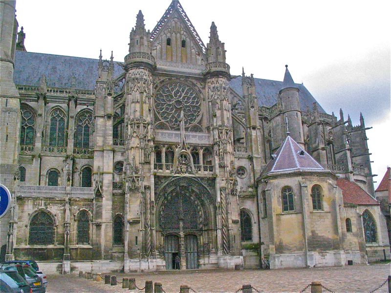
The cathedral from the south
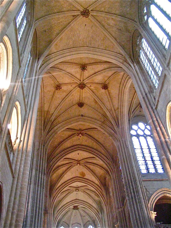
Interior vaulting

The east entrance

Machine gun impressions, reminding us that life if suffering no matter what era you live in

I also stopped by the tourist information center, which is in the Cathedral square and picked up a walking map of the town. I had found that I had walked most of the old town already and so decided to venture outwards somewhat from the old town to some of the newer areas. It did not take long to get lost because the route had me going up a well concealed staircase that skirted several buildings. Through careful backtracking, I finally found it. There are 4 walking tours through the town, so do stop by the tourist center for you map.

Exterior and interior of the hunting museum


I am glad that I took a couple of extra days before my conference, because once it started, I was a captive from 8am to 10:30pm and would not have seen a thing otherwise. My three destinations covered the gamut. The Chateau de Chantilly gave me a taste of the grandeur and decadence of the aristocracy, the Royaumont Abby peace and industry of the cloisters, and Senlis the narrowness (both physical and mental) of a medieval village.

A more modern part of the walking tour

greenway near the old walls

Once again I apologize for the quality of the photography. Time to get a new travel camera!

Sunday, April 4, 2010

France: Chateau de Chantilly

The Chateau de Chantilly

The grand houses of Europe no longer evoke the bitter envy they must have once inspired in the groveling peasants who stood forever outside their gates but their architecture, whimsy, and expansive grounds still thrill. You can't walk through their high porticoes without secretly saying to yourself that if you had been born in that era, surely you would have been one of the lucky ones. Foolish delusions. Even today, we plodding tourists are no more a member of the privilaged classes than the grooms and maids were several centuries ago. Society is a pyramid and you and I dear readers are most likely not balanced on the apex. Welcome faceless minions to history.

The Chateau from the road into town

If you can handle the brutal dose of humility, a visit to the Chateau de Chantilly is a world class tourist destination north of Paris. It was a 10 minute drive from the location of a meeting I was attending, so I spent half a day wandering around the grounds, trying to stay awake after my 24-hour travel odyssey. The weather was cold and dreary, and the Chateau gardens were not at their peak but it was pleasant none-the-less. It is not difficult to imagine, the lavish and naughty (as only the aristocracy could be naughty) entertainment in the formal gardens and silk draped boudoirs. Now the stones are cold and the gravel pathways are tromped by an never ceasing troop of peasants from all over the world. The horror of it.

Note the mote and the riff raff gathering in the courtyard for their glimpse of the gilded age.

My only interior shot. This was the Duke's private chapel

Rather than try and write a whimsical history of the Chateau, I am just going to plagiarize directly from the site's website
(http://www.chateaudechantilly.com/chateauchantilly/uk/histoire.html).

The grand stables. This was the first building I saw when I came through the round about and I thought IT was the chateau. Some seriously pampered horses there.

A close up of the stables.

"From 1386 to 1897, the domain was passed on by inheritance to different branches of the same family, without ever being sold. The ORGEMONT family (14th - 15th centuries), followed by the MONTMORENCY family (15th - 17th centuries), one of the most powerful families in the kingdom and which largely contributed to its development, especially in the time of Le Connétable (the Constable) Anne de Montmorency (1493 - 1567). A friend of kings François I and Henri II, he commissioned Jean Bullant to build the Petit Château. Later came the Bourbon Condé family (17th - 18th centuries), cousins of the kings of France, the most famous of whom, Le Grand Condé, entrusted the lay out of the grounds to André le Nôtre, and finally Henri d'Orléans, Duc d'Aumale (1822 - 1897), the son of King Louis Philippe of France."


Another view of the Chateau with the rain clouds looming

"The Duc d'Aumale inherited Chantilly from his great uncle, the Prince de Condé, when he was eight years old, in 1830. He had the Grand Château, which was razed to the ground during the French Revolution, reconstructed in order to house his magnificent collection of paintings, drawings, objets d'art, books, etc. In 1884, the Duc d'Aumale, who had no direct heir, bequeathed the Chantilly estate to the Institut de France, subject to the Condé Museum being opened to the public. The Duc d'Aumale's wish was for the estate to use, maintain and help restore this magnificent cultural heritage. Not only the Château and the Condé Museum, but the Grandes Ecuries, which has housed the which has housed the life museum of the horse"

A statue near the entrance with the stables in the background

The guest quarters near a private lake

The stables were under renovation while I was there, so I only got to peak inside. The exterior is more imposing than the Chateau itself. Personally, I enjoyed the exterior architecture more than the interior rooms and museum but the price of admission includes both.

Heading down the steps into the French garden and looking back at the Chateau

The mote on the garden side

I did have lunch in the La Capitainerie, which is contained with the historic kitchens of Vatel, the famous inventor of Chantilly Cream. The menu is buffet only. One could choose from a combination of h'dourves, entrees, and desserts. The h'dourves were by far the best. There was shrimp, cut meats, cheeses, and lots of bread. Sitting down in the throws of jet lag was dangerous, however, and after lunch I quickly moved on to the gardens.

The statue of the Constable on the grand avenue. That small cut in the trees beyond is a long avenue through which the King would arrive.

A corner

In the forest of the Chateaus is a petite Hameau or village, which was the model for the one at Versailles. The idea was to mimic the poor hovels of the poor. At Versailles, Marie Antoinette used to pretend she was a milkmaid. It might have gone better for her if she had spent time with the real people instead of Disneyland commoners. The interiors of these fake hovels were not dirty and poor. Instead they were the 18th Century equivalent of a Las Vegas theme hotel, wild, sensual, and wildly decorated. In the Hameau, reality never quite made an appearance.

A period statue. When will those bows come back in style?

In the latter part of the 18th Century, there was a trend away from formal gardens and towards a more natural view of nature. At this point a fake waterfall was constructed to mimic with wildness of France. I had to laugh at this artifice. Compared to the wilds of Colorado, this garden was as tame as a bedtime story.

A final view from out in the French gardens

Victorious in my ability to stay awake, I took one last glimpse of the Chateau and headed to my hotel and a most welcome hot shower.

Saturday, April 3, 2010

Back from France

(left: the entrance to the Chateaux to Montvillargenne) I am behind in my blogging because of another spring storm in Colorado that prevented me from getting up into the mountains. Instead I stayed home and did my taxes . I also ended up on a week long business trip to northern France from which I have just returned. It is that subject that I will post on over the next week or so.

I was in France for a meeting at the Chateau de Montvillargenne, which is located near the towns of Chantilly and Gouvieux. I rented a car and drove around the area for the weekend before the meeting. It was cold and drizzly most of the time. Spring is late this year and all the greenery was still in hiding, which is a shame because this area is thickly forested and I was looking forwarded to walking in the woods.

The trip was long and exhausting, as international travel always is. I never did get over my jet lag. The hotel was intriguing from the exterior but nondescript on the interior. It is not a place I would recommend as a tourist destination, but it was very convenient as a conference location. The grounds were completely fenced from the surrounding area, so one really did need a car even to pop into town for dinner.

A close up of the entrance. In summer those vines are flushed out with greenery

Over the next few posts, I will describe a few of places I visited. I borrowed a small travel camera from a friend. I think it is starting to fail because most of the photos came out grainy. It was overcast most of the time, so I did have the ISO set to 400, which did not help. I've decided to post the photos and commentary anyway because I just can't help myself. Don't worry though, I have a couple of new trails in the queue this weekend that will hopefully add to my library of Colorado's pleasures.

Friday, March 12, 2010

Meadow Mountain (near Minturn) Snowshoe

Distance: 7.3 miles roundtrip (9 miles roundtrip to the Line Shack)
Elevation: 7,799 ft - 9,191 ft
Elevation Gain: 1,500 ft
Dogs: Off leash (run baby run)

Old cabin on the Meadow Mountain Trail

A meadow mountain snowshoe is not a wilderness experience but it sure is fun. Meadow Mountain is a old road that switchbacks through ranching country. It's wide open spaces make for expanse views of the adjoining hills and the occasional ruins of 19th Century cabins adds an historic appeal.

Starting up the road. Note that it is well tracked by snowmobiles

A typical open expanse

A small cloud wave

If you don't want to travel up the road, there are plenty of hillsides covered in waist-deep snow to frolic in. Zigzagging up and down one of these hills would be fun if you like breaking trail, falling down, and burning serious calories. On a sunny day with no wind, you might just be doing it in shorts. This trail is like an overheated frying pan. Toss in some wind though and it might just freeze the eyeballs out of your head. There is very little cover. The road itself was well churned by snowmobiles. We worn YakTraks instead of snowshoes. That did make the going a little harder, however.

Another switchback with Aspens in the distance. The small dot in the middle of the picture is Ginger, who is running 100 mph up and down the slopes!


The switchbacks seemed never ending but they were hard to cross cut from below, you just couldn't quite tell where the road was.

The route begins at the far end of a small and very active tubing resort a mere 0.4 miles south highway Hwy 24 from I-70 (Dowds Junction Exit). The parking lot for this facility was packed, so we parked in the lot of the adjoining Holy Cross Forest Service Station. To start up the road, look for a small trailhead sign next to the white house adjacent to the tube pull. Snowmobilers use the road, but during the 4 hours we were out, we only saw one set and they were going very slow. Despite the hordes of cars in the parking lot, we saw only other snowshoer on the trail.

Aspens

A view looking southeast

Old fences, corrals, and cabins dot the area.

Be aware that several guidebooks indicate that the Line Shack (which is shown on the National Geographic Topo of the area) is 3.5 miles up the road. After traveling 3.6 miles we had not found it and started hunting through the woods before giving up. While eating lunch, the aforementioned group of snowmobilers passed us coming back down the trail. I asked the guide and he said the cabin was another mile further up the road. Sure enough, the Forest Service description of the route (which I looked up later) indicates the cabin is 4.5 miles up the road, so ignore the guide books.


I liked the shadows the Aspens made in the snow

A view looking northeast

While much of this route is across open hillsides, towards the end there is a very large Aspen grove. In fact Aspens can be seen far across the valley on other hillsides. This makes me think this trail would be a great fall color hike. I plan to return to find out.

Looking east into the town of Minturn

An example of the road near where we turned around. Because the road is so wide we did not feel hemmed in from the trees.

Coming back down the road is not as much fun as going up it. You can minimize the drudgery by cutting across the switchbacks or sliding on your tail wherever possible. This cut at least a half mile off the return, which when you are cold and hungry is a blessing.

Friday, March 5, 2010

Gold Dust Snowshoe (Central Section)

Distance: 5 miles roundtrip
Elevation: 10, 333 ft - 10,700 ft
Elevation Gain: 267 ft
Dogs: Off Leash

The deep trench and shelf-like aspect of the Gold Dust Trail.(Photo by Cratch)

The central portion of the Gold Dust Trail (County Road 50 to Forest Road 801) out of Como is a serene and easy traverse along a long forgotten flume that once diverted water from North Tarryall Creek to mining operations in the upper Tarryall Drainage. This nearly flat trail weaves lazily through a mixed Lodgepole and Ponderosa Pine Forest with only a few "peak-a-boos" to the east. It exudes solitude and is a great trail for novices or those that like to feel the hush of winter.

The trailhead off of Country Road 50. Note the sign says 698. The map lists this trail as 653 (Cratch).

(On the left: A rare photo of the author who is usually behind the camera. On this trip she ignominiously forgot it. All photos are credited to Suzanne Cratch or another anonymous participant. Thanks Ya'll!)

On this trip the snow was at least 3 feet deep and piled in soft, rolling drifts. Not a pine needle stirred and the gray skies hung over the area like a comforting blanket. Some group had broken trail before us, which made the going much easier. Their passage resulted in a hip-width trench with 1.5 to 2 ft sides that had more curves to it than a bobsled run.
All of the elevation gain on this trail occurs in the first quarter mile of the trail. This trail is very well marked. Blue blazes dot the trees almost every few feet or so it seemed. There are even blue arrows at strategic intersections.

As we were sloshing along, I could not figure out how this trail could be so flat and so continuously curvy until I returned home and read about the flume. My instincts had been right. There was something not quite natural about our route. The labors of long dead miners had created an artificial topography. I am sure they never envisioned the flume being used by under exercised suburbanites looking to escape the city. Burning calories was not a problem for those hearty pioneers.

A less deep trail segment (Cratch)

One of the infrequent "peek-a-boos" (Cratch)

To get to this trail, take 285 to Como (9 miles west of Fairplay). Follow Boreas Pass Road (County Road 33) until it turns sharply right at the Peabody Trailhead (Robert's Cabin). This is the junction with County Road 50, which continues straight for several miles until it dead ends at a gate. 1.0 miles up CR 50 is a small vertical Forest Service sign near a trail register and large wooden home. Both are on the right hand side of the road. Parking is just along the side of the road. This trail is well marked on National Geographic Map 109. In the winter, Como is totally shut down, so don't expect any coffee shops or bathrooms nearby. The closest are in Fairplay.

The sign for the Tarryall Creek (Cratch). Road 801 is another 800ft beyond.

Suzanne and Laura play in the deep snow near our turn around point.


Como is probably not your list of places to visit this winter, but this trail should not be overlooked by those seeking an outdoor adventure unmarred by exessive panting. I rarely recommend trails totally in the trees, but this trail touched me. Its soft lines, and quiet aspect have a meditative quality that is worth experiencing.

Just before the road is an open meadow with a nice view of Boreas Mountain (13,082 ft).

Our lunch in the snow. What you can't see is that I am sitting on an inflatable butt pad and sipping hot coffee from a thermos. We outdoor divas like our creature comforts!

Friday, February 26, 2010

Lilly Pad Lake Snowshoe (via the Ryan Gulch Trailhead)

Distance: 3.4 miles round trip
Elevation: 9,619 ft - 9,915 ft (high pt is 10,003 ft)
Elevation gain: 314 ft (net), 900 ft (cumulative)
Dogs: Technically on leash (wilderness), but nobody does

Lilly Pad Lake

The winter trail to Lilly Pad Lake in Silverthorne is a short and serene winter outing. It is great for an afternoon dog walk or a post-death march must-I-really-get-off-couch excursion. The trail winds through an open Lodgepole forest, that is admittedly mostly beetle kill. Covered in snow, however, the stark brown trees lose their funereal aspect. There are at least two pleasant meadows en route and the lake, while surrounded by trees, is a pleasant if uninspiring destination.

The trailhead

The storage tank (covered in snow)

There are several routes to Lilly Pad Lake. This post profiles the route from the Ryan Gulch Road Trailhead, which also serves Buffalo Cabin. The Lilly Pad Lake trailhead is at the far end of the parking area and is marked by a large trail kiosk. The trail heads sharply upwards for a 300 ft elevation gain in only 0.17 miles. At the top of this lung buster is a small storage tank and metal tower. The best views on the trail occur in this short stint. Grays and Torreys, Lake Dillon, Square Top Mountain, and the booming Starbucks up highway 6 are all visible on a clear day.

Intersection with the Salt Lick Trail

One of the more scenic meadows

Other milestones along the trail include a nice meadow at 0.82 miles (9,846 ft), the junction with the Salt Lick Trail at 1.2 miles (10,003 ft), a very large meadow at 1.64 miles (9,927 ft), and finally the lake at 1.7 miles (9,915 ft). You may be able to tell by the list elevations, that this trail goes up and down quite a bit. If one is fresh, the hilly terrain features will provid a welcome cardio vascular boost. If one is recovering from a 14er, the small hills will cause unwelcome quad burn and impolite cursing in a foreign language.

Snow splattered Lodgepole Pines. This tree gets its name from Indians who used the narrow trunks as the center pole of their homes.

On this trip, Silverthorne had just woken up from a nice winter storm. Each narrow Lodgepole tree trunk was splattered with snow reminiscent of a girls-gone-wild whipped cream frat house initiation. Only the north sides of the trees were so decorated. Considering that I did this trail on Valentines Day, I was feeling very left out of Mother Nature's coed frivolity. The large heart that someone had stomped in an adjacent pond, made up for it however.

The lake was covered with 6 inches of snow. I was not brave enough to walk all the way out, but others had.

A Lilly Pad Lake snowshoe is not a stunner, but it is short, easy, and accessible. These are three things that should not be discounted. Sooner or later you'll be looking for a trail just like this.

Peak 1 (12,933 ft) of the Tenmile Range is just visible above the trees. On this snowy day we hardly saw it.

Tuesday, February 23, 2010

Egg Yolk Lichen

Egg Yolk Lichen (Candelariella rosulans)

The only color you see this time of year are the bright colors of lichens clinging doggedly to the rocks. They stand out like face paint at the Superbowl.

You've heard the torrid story of lichens haven't you? It is the naughty tale of Freddy Fungus and Alice Algae and how they took a lichen to each other and now live in SIN-biosis. I giggled girlishly when my mother first told me that story on a summer camping trip. Ah, the things that entertained us before iPods. Alice is not quite the perfect kept woman. While Freddy provides the home she provides the food. Because of this, lichens only need air and water to grow.

Egg Yolk Lichens (Candelariella rosulans) are common throughout Colorado. They are crustose in form and can cover huge rock faces. I like lichens because they remind me that Nature can colonize any habitat no matter how harsh. A little chartreuse on a dreary winter day is not bad either.

North Rock Creek Snowshoe

Distance: 4 miles round trip Elevation: 9,180 ft to 9,780 ft Elevation Gain: 600 ft Dogs: Off leash until the wilderness boundary North...