Saturday, January 30, 2010

Great Sand Dunes

Distance: 3 miles round trip
Elevation: 8,050 ft to 8,690 ft
Elevation Gain: 640 ft
Bathroom at Trailhead: Yes
Dogs: Not allowed
Date Hiked: 2 July 2004 and 22 July 2007 (photos from both)

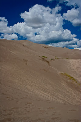
The Great Sand Dunes. The scale is lost in this picture even with the tiny people.
A detail of the sand grains

The Great Sand Dunes in the San Luis Valley are one of Colorado's geologic wonders. They cover 30 square miles and rise to over 700 feet from the valley floor. I have never made it all the way to the "High Dune" which this post depicts, because I have always visited the dunes on my way to someplace else. Playing in the sand is hard to resist, however as the many hordes on the dunes attest.

The Medano Creek is a favorite spot for young children to plan in.
The dunes ever shifting shades of color draw people time and again.

There is no trail up the dunes, but it easy to follow the route of others. The "High Dune" is merely the highest point visible from the parking lot. It is not the highest point in the dunes. That edifice is another 1.5 miles beyond the high point.

Looking east from part ways up the dunes. That line in the middle of the picture is a string of people walking down.

Climbing along a ridge

While elevation gain is the goal of most Colorado hikers, I find that the dunes themselves and not the vistas are the best part about a visit to the park. The varying shades of brown, the clouds, and the welcome warmth (even in summer) of the sun baked crystals are a unique experience.

Looking east farther up the dunes

Sand and blue skies. What is not to love?

I have yet to visit the dunes without at least rolling down, leaping down, or pushing someone else down the hills. I have done yoga poses and crawled about in desert death-like throws. Such wanton behavior barely makes a dent in the shifting surface and is totally ignored by the numerous other adult-children absorbed by their own frolics. What is it about sand that makes people want to play? Perhaps we need a few more sand boxes in corporate America.

Following everyone else's trail
There are 7 species of insects in the dunes that live no where else, but the only large creature that can survive the harsh conditions is the Kangaroo Rat. Most of the other visitors are of the 2-legged kind.

Climbing the dunes is harder than it looks. You slip and slide and struggle upwards.
Small grasses hold the dunes in place here and there.
There are other great places to go within the Great Sand Dunes National Park, but they have their downside. To get there, one must let some of the air out of ones tires and drive along roads that are covered in sand most of the time. There is no ideal place to refill ones tires once done.
There is a small visitor's center and a large picnic ground, which was completely full the last time I visited.

The winds create abstract designs in the sand.

Coming back down and looking out into the San Luis Valley
The Great Sand Dunes were formed when a giant lake, that filled the entire San Luis Valley finally dried up, leaving large deposits of sand. Winds from the west blow the sand up against the Sangre de Cristo Mountains to the east while at the same time periodic   winds have sent the sand back eastward. The juxtaposition of these two forces has piled the dunes to record breaking heights.

Everyone in Colorado needs to visits the dunes at least once in their life. Their uniqueness, their beach vibe, and their scenic beauty are worth even a short stop over.

Sunday, January 24, 2010

Independence: Ghost Town

Ghost towns and mining ruins are everywhere in Colorado. You see them from the highways, you trip over them on the trails, and you read about them in the newspapers.

Independence is one of the better known ghost towns. It is located 15.5 miles from Aspen and 44 miles from Leadville atop Independence Pass (12,095 ft) and so is visited by many of the travelers on Highway 82.

Independence was founded in 1879 when Leadville miner Billy Belden struck gold in the summer of that year. Called by many names during its short lifetime (Belden, Chipeta, Sidney, Farewell, Mammoth City, Sparkhill, Mount Hope, and Farwell) most modern types know the town by its current name of Independence.

There is a small guided trail through the ruins today and the cabins are being slowly restored by the Aspen Historical Society. Even in spring, the pass can be cold and snowy as the pictures in this post attest (they were taken in May 2005). The peaks surrounding the ruins have been eroded by the winds into smooth edifices that stand witness to the transitory nature of human endeavors.

Before the railroad reached Aspen, Independence Pass was the primary route between Leadville and Aspen. Independence became a transportation hub as well as a mining camp. The gold did not last long, however and by 1912 the town was dead.

A restored cabin


If you are every driving on Highway 82, don't blow by Independence. Take a half and hour and walk around. Try to imagine living in a cabin at 12,000 ft in the middle of winter. Your SUV's heated seats and ipod connector will be appreciated that much more!

Thursday, January 21, 2010

Blue Lake-Lower (Sneffels Wilderness)

Distance: 6.6 miles round trip
Elevation: 9,400 ft - 11,000 ft
Elevation Gain: 1,600 ft
Dogs: On leash in the Wilderness Area

View from the Summit of Handies PeakThe turquoise waters of Lower Blue Lake

Blue Lake, near Ridgeway and Mt. Sneffels (14,150 ft) is a wonderful hike. The surrounding peaks are jagged, the drive in is almost as good as the hike, and it is relatively easy for the area.

Mt. Sneffels (on the left) dominates the view on the drive to the Blue Lakes trailhead

Mt. Sneffels from the trail

I did this hike back in September of 2006 when I flew my parents out for a week of leaf peeping in the San Juans. For fall color, you can't beat the San Juans and Ouray is a great location to try and do it all. On this trip we drove highway 550 and took the Durango-Silverton Railroad. Near the end of the trip, we met a rather nasty snowstorm that made driving 550 to Silverton a white knuckled affair for my father who had to pick my mother and I at the train depot. To this day, he puts highway 550 and Red Mountain Pass as one of the scariest things he has ever done.

A typical trail segment

Another horrible view

The trail to Blue Lake, however, has none of these horrors. Instead, it wanders in and out of towering Spruces with occasional expansive views back out towards Ridgeway as well as up close glimpses of the Sneffels range.

Much of the trail is wide open
Engleman Spruce is the dominate tree on the trail

We only met two other groups on the trail, which was well maintained. With only a few steep sections, we also found it easy to do. You can continue on above the lake to Blue Lakes Pass at 13,000 ft. Since my parents were waiting for me back at the house we rented, I turned around at the lower lake.

Looking back down the trail towards Ridgeway

The lower lake is just beyond those trees
The lower lake itself is small and shallow but a lovely turquoise color. The peak directly in front is dramatic and dominates the scene. Since I did this hike in the fall, all the tundra was golden and this contrasted sharply to the peaks, which had already had their first snowfall. The best views of the lake, are farther up the trail however, so if you do hike to Blue Lakes pass be sure to bring a camera.

Flat tundra dominate the area around the lower lake
If I am in the Ouray area again, I will certainly hike this trail, but I will allow enough time to make it up to the Pass. The views along the way are reportedly very memorable.

A close up the lake and the slopes beyond

Thursday, January 14, 2010

Crag Crest

Distance: 10 mile loop
Elevation: 10,152 ft - 11,189 ft
Elevation Gain: 1,037 ft
Bathroom at Trailhead: Yes
Critters: MOSQUITOES
Dogs: Off leash
Date Hiked: 1 July 2005

(On left: Butts Lake viewed from the top of the Crag Crest ridge)

Crag Crest is located atop Grand Mesa, one of the largest flat-topped mountains in the world. Grand Mesa is clearly visible from I-70 but its scope must be appreciated up close. There are over 300 lakes on top of Grand Mesa, each one teaming with blood-thirsty mosquitoes ready to drain you to within an inch of your life. While the denizens of Minnesota or Alaska may yawn with ennui at such a declaration, I can assure you, that to a Coloradoan, Grand Mesa is a horrifyingly primeval place. I actually pitched a full-blown girlie fit 5 minutes up the trail and went screaming back to the car in search of DEET and a flame thrower. It was not my finest moment. I wish I could say it was PTSD from all those attempted hikes in the piny woods of Mississippi but the reality is was shear neurosis with a capital N.

To make matters worse, I attempted this trail on a 4th of July weekend (2005), and there was so much tree fall to traverse and so much snow on the route that I had to content myself with an out and back scramble. The potential of the trail was obvious, however. From the top of the crest are stunning views. Whiplash is a hazard as you gaze back and forth between the lakes on the mesa and the rolling hills in the distance.

Upper Eagleston Lake
Bullfinch Reservoir

There are two trailheads for this loop. I started at the east trailhead near Eagleston Lake. There is a campground there but it looked more like a war zone with all the downed trees and pine bows strewn everywhere. It was quite the outward bound adventure to climb over and under the fallen logs while at the same time slapping mosquitoes to the syncopated rhythm of my breathing.

A slushy snowfield on the route up. The dogs liked it more than I did.
The trail, when it was visible was well maintained.

The trip was pre-blog, so I took no careful notes of the route and only a few pictures. Take this post as an incomplete introduction to the area. To date I could not find any other detailed trip reports, so my recollections are better than nothing.

Another view of Butts Lake

The trail does ascend through the trees past Upper Eagleston Lake, a very scenic spot and continues on to Bullfinch Reservoir, which was filled with tree stumps. Beyond this point the trail ascends more sharply up a series of switch backs, some snow covered, to a narrow rocky crest. The trail continues for another 3 miles along this formation. I stopped for lunch near the top. Since I knew the route was blocked at the western end, I turned around about 3.5 miles lamenting the fact that in Colorado July does not always equal summer.

Looking to the north into a narrow but enticing valley
Looking out over another lake
Crag Crest is a classic and I hope to return someday to complete the route. I am sure that with a little more pre-planning and a set of steel lined skivvies it would be a wonderful experience. There are cabins and campgrounds galore on top of Grand Mesa that are worth checking out in their own right.


Looking northeast
Glacier Lilies by the shore of Upper Eagleston Lake.  Note all the snow in the trees.

Sunday, January 3, 2010

Jim Creek Snowshoe

Distance: 6 miles round trip
Elevation: 9,230 ft - 10,113 ft
Elevation Gain: 883 ft
Dogs: Off leash
Tags: #snowshoe, #winterpark, #coloradooutdoors

A rare glimpse of the mountains to the northeast from the Jim Creek Trail
Jim Creek near the Winter Park Ski Resort is an easy snowshoe suitable for novices or those just beginning their winter conditioning. The trail is wide, well packed, and the elevation gain is extremely gradual. The trail is in the trees most of the time, and we were the only ones in sight. Solitude reigned supreme.

The trail head kiosk
The trail head is located across Highway 40 from the Winter Park Ski Area. The route begins next to the trail head kiosk in the G-parking area of Winter Park. The trail starts to the right on a boardwalk labeled the Discovery Trail. On the other side of the boardwalk, head left. You will pass under a large, cream-colored water pipe shortly thereafter. At 0.8 miles is a four-way junction with a sign for the James Peak Special Protection Area. Continue straight at the junction. At 1.4 miles is an Adopt-a-trail sign, at 2.1 miles the trees close in rather dramatically, at 2.54 miles we hit 10,000 ft, and at 2.8 miles (10,113 ft) we turned around.

The water pipe and National Forest Boundary
While in the trees most of the time there are occasional views of the side valley walls and one nice, but brief view of the summit of James Peak. Being in the trees has one main disadvantage, you are in the shade even if the day is beautifully sunny. It is much harder to stay warm without the welcoming Colorado sunshine.

Still near the parking area, the trail passes by a large picnic ground. The building is a bathroom that was closed.

Dark trees is the norm on the Jim Creek trail
Another open area
The spot at 2.1 miles where the trees close in was very intriguing. The trees seem to double in height and are so close to either side of the trail that I almost felt like walking sideways. The amount of snow bulging from every bough made this gauntlet feel almost cozy despite the chill. A few Starbucks gift cards handing from the branches would have made the experience complete!

The trees start to get taller
Your turn around point is going to be determined entirely by your energy level. Just past 2.6 miles, the trail ascends a series of short switch backs. After this point, however, the trail is more of a bushwhack. There are branches to duck, and the frozen creek is close at hand.

The one decent view of James Peak
The trees close in

North Rock Creek Snowshoe

Distance: 4 miles round trip Elevation: 9,180 ft to 9,780 ft Elevation Gain: 600 ft Dogs: Off leash until the wilderness boundary North...