Distance: 3 miles round trip
Elevation: 8,050 ft to 8,690 ft
Elevation Gain: 640 ft
Bathroom at Trailhead: Yes
Dogs: Not allowed
Date Hiked: 2 July 2004 and 22 July 2007 (photos from both)
 The Great Sand Dunes. The scale is lost in this picture even with the tiny people.
 A detail of the sand grains
The Great Sand Dunes in the San Luis Valley are one of Colorado's geologic wonders. They cover 30 square miles and rise to over 700 feet from the valley floor. I have never made it all the way to the "High Dune" which this post depicts, because I have always visited the dunes on my way to someplace else. Playing in the sand is hard to resist, however as the many hordes on the dunes attest.
 The Medano Creek is a favorite spot for young children to plan in.
 The dunes ever shifting shades of color draw people time and again.
There is no trail up the dunes, but it easy to follow the route of others. The "High Dune" is merely the highest point visible from the parking lot. It is not the highest point in the dunes. That edifice is another 1.5 miles beyond the high point.
 Looking east from part ways up the dunes. That line in the middle of the picture is a string of people walking down.
 Climbing along a ridge
While elevation gain is the goal of most Colorado hikers, I find that the dunes themselves and not the vistas are the best part about a visit to the park. The varying shades of brown, the clouds, and the welcome warmth (even in summer) of the sun baked crystals are a unique experience.
 Looking east farther up the dunes
 Sand and blue skies. What is not to love?
I have yet to visit the dunes without at least rolling down, leaping down, or pushing someone else down the hills. I have done yoga poses and crawled about in desert death-like throws. Such wanton behavior barely makes a dent in the shifting surface and is totally ignored by the numerous other adult-children absorbed by their own frolics. What is it about sand that makes people want to play? Perhaps we need a few more sand boxes in corporate America.
 Following everyone else's trail
There are 7 species of insects in the dunes that live no where else, but the only large creature that can survive the harsh conditions is the Kangaroo Rat. Most of the other visitors are of the 2-legged kind.
 Climbing the dunes is harder than it looks. You slip and slide and struggle upwards.
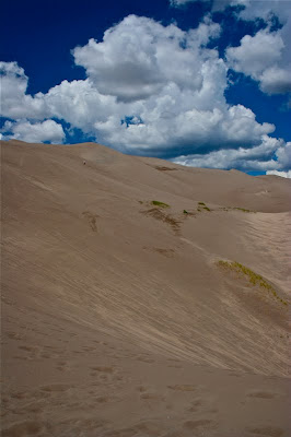 Small grasses hold the dunes in place here and there.
There are other great places to go within the Great Sand Dunes National Park, but they have their downside. To get there, one must let some of the air out of ones tires and drive along roads that are covered in sand most of the time. There is no ideal place to refill ones tires once done.
There is a small visitor's center and a large picnic ground, which was completely full the last time I visited.
 The winds create abstract designs in the sand.
 Coming back down and looking out into the San Luis Valley
The Great Sand Dunes were formed when a giant lake, that filled the entire San Luis Valley finally dried up, leaving large deposits of sand. Winds from the west blow the sand up against the Sangre de Cristo Mountains to the east while at the same time periodic winds have sent the sand back eastward. The juxtaposition of these two forces has piled the dunes to record breaking heights.
Everyone in Colorado needs to visits the dunes at least once in their life. Their uniqueness, their beach vibe, and their scenic beauty are worth even a short stop over.
 I used to drive by the Lohr-McIntosh farm all the time when I lived out east of I-25. It is located on Hwy 66 on the way from Longmont to Lyons and Rocky Mountain National Park.


