Thursday, April 9, 2009

Day 5: Walnut Canyon Rim Trail

Distance: 1 miles round trip
Elevation: 7,000 ft
Elevation Gain: None

Ruins in an alcove at Walnut Canyon. You can see this set from the Visitor's Center.

Having exhausted all the ruins near Sedona, the family unit decided to head north towards Flagstaff, which is 3,000 feet higher, and quite cooler than its trendier cousin to the south. I have always like the Flagstaff area because of its Ponderosa pines, which smell like my happy childhood summers camping around the west.

We hit two National Monuments near Flagstaff, the first one being Walnut Canyon. I am loath to pass up a tourist attraction, particularly if a new refrigerator magnet can be earned. I hate to say it, but the magnet was the best part of the outing.

The dwelling trail viewed from the Visitor's Center.

Walnut Canyon National Monument contains a series of cliff dwellings that are simplistically constructed into the canyon walls. There are over 300 steps down into the canyon to view the more impressive ones. There was no way my Mother, who had gamely managed to get around thus far, was going to handle that. Instead, we took her out onto the nice viewing platform that angles downward 30 feet or so below the Visitor’s Center. You can see some dwellings from there as well as the canyon floor.

A typical portion of the Rim Trail. You can see a few of the dead trees in the distance. On part of the trail they were everywhere.

We did walk the Rim Trail, which also has nice views of the canyon. There were a lot of dead trees in this area that turned out to be caused by Pine Beetle kill. We saw the tracks and scat of Mule Deer and one Juniper Titmouse that I managed to get a very blurry picture of. There are ruins of a pit house on the Rim Trail that is mildly interesting.

Looking down to the canyon floor. Most of the trees had yet to leaf out.

I don’t think I would drive 300 miles to see Walnut Canyon, but if you are in the area it would make a pleasant excursion. In milder weather, we were quite nipped after Sedona, a leisurely picnic on site would also be pleasant.

Day 5: Fay Canyon Hike

Distance: 2.4 miles round trip
Elevation: 4,500 to 4,800 ft
Elevation Gain: 300 ft

Red rock walls of Fay Canyon

Once again I awoke early to get in a hike before my parents awoke. This day I chose Fay Canyon because my new guidebook said it was very pretty and was quite short. It took me 15 minutes to drive to the trailhead from our vacation rental, so I did not have a lot of extra time to spend.

Beginning of the trail. It was wide, flat, and sandy.

The canyon is indeed very scenic, and the early morning sun glinting off the upper rocks in pleasing sepia tones filled me with peace. Early spring before the sun reaches the canyon floor may not be the best time to hike this trail despite the visual effects, however. It was cold and I found myself hustling along to stay warm, my gloved hands curled into claws in my jacket pocket.

Morning sunlight on the canyon walls seen from half-way up to the arch.

Unlike the Andante and Thunder Mountain Trails, which I took my dad on the day after this, this trail really is easy. The main trail is very sandy with minimal rocks. I could have taken my mother on this trail without difficulty.

The arch viewed from the main trail

The red rock walls that progressively narrow as one heads deeper into the canyon dominate the senses. I remember chatting with a forest service ranger at one of the cliff dwellings and she said that the best hikes in Sedona are usually the easiest. Fay Canyon certainly fits that description.

For the more adventurous and sure-footed soul, Fay Canyon has an added attraction of a natural rock arch up the right hand side of the canyon. The trail to this arch, at 0.6 miles in, is marked with a cute arch cairn, so it is very difficult to miss. The trail to the arch is a scramble, however, that several times required both of my hands. It is highly eroded, very rocky, and bordered by hungry Prickly Pear Cactus. A slip here would result in more than a bruised behind!

Rock ledge near the arch, which is straight ahead.

The climb to the arch is well worth the effort, however. The views of the canyon are spectacular and at this hour in the morning, I had the entire place to myself. Two songbirds were cajoling amongst the rocks making quite a racket and the air was perfectly still. I would have loved to have lingered but my time was short.

Cross canyon walls silhouetted through the arch

The trip back down the trail was very steep and slippery. I had to crab my way down in several spots. Fortunately, there was no there to see such an ignomious decent.

Towards the end of the canyon, the trail narrows and a canopy of scrub oaks obscures the views. The trail itself does not go to the geographic end of the canyon. Instead it stops at a large rock fall near a very obvious rock thumb. While it looked completely possible to scramble over this fall and continue on, I had a breakfast date I could not miss and so turned around.

Trail narrows towards the end

It took me 1.5 hours to head up the canyon but only 0.5 hours to get back, so if you don’t scramble up to the arch, the hike can be very short indeed.

Rock thumb marks the end of the official trail

After the hike I swung by the Enchantment Resort for a cup of great coffee. I found this resort so appealing; I made reservations for us for lunch the following day. It is located in an adjacent canyon with wonder views of the red rocks.

Friday, April 3, 2009

Day 4: Slide Rock State Park Vista Trail

Distance: 1 mile round trip
Elevation Gain: Negligible

Standing on the bridge looking up at the park. The water shoot it at the far end of the photo.

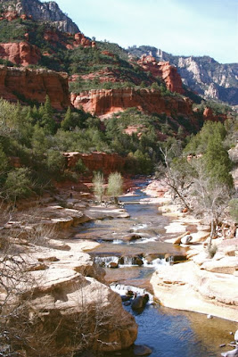
We drove up Oak Creek Canyon for a ways after visiting Tuzigoot and Jerome. Oak Creek Canyon is not as spectacular as I thought it would be. It is mostly the creek and trees and not as many red rocks as I anticipated. Most of the trees were barren but I suspect in the heat of summer, those trees and that water would be a welcome respite.


Red rocks along the trail. It was late afternoon and I was shooting into a harsh sun.

One of the most popular areas in Sedona is Slide Rock State Park. Here you can slide through a narrow slot of cool water. In March, it was far too cold to even contemplate getting wet. In fact it was not until the day we left that I could even wear shorts.


Just past the bridge over Oak Creek at the southern end of the park is a parking area and a short trail through the scrub oaks. This trail follows the road back down to the bridge for a nice panorama of the park itself. While short, this little trail is very pleasant. It gave us a chance to view some of the few red rocks in the area.

Another view of the park near the bridge. You can see a few hearty souls playing in the water.

Sunday, March 29, 2009

Day 4: Tuzigoot Sinaguan Ruins

Standing on the roof of Tuzigoot looking north. The light brown near the cliff is the marsh.

Tuzigoot, which is Apache for crooked water is the remains of a Sinaguan pueblo. It also turned out to be my mother’s favorite site on the trip. She liked the idea of seeing an entire village. I liked it because they have reconstructed the roof of the highest part of the structure so you can stand on the top and view the entire area. This might be the viewing loving Coloradoan in me or it might be the fact that the Sinaguans lived on their roofs, and this reconstruction provides a glimpse into that experience.

Looking up at the ruins from the far southern extent of the walkway. There were two gringo women here conducting some faux Indian ritual. The doubt the original inhabitants would have appreciated such misguided beliefs.

This ruin is near Cottonwood, which is 20 miles east of Sedona. We combined this visit with a trip up to Jerome, an old mining village high up Mingus Mountain. Jerome turned out to be such a dud that I won’t bother blogging it. If you go to Tuzigoot, combine it with Palaki and Honaki for a ruins blitzkrieg.

Looking south to the point where I took the previous picture. You can see the green trees and lush farmland of the Verde Valley. It is not difficult to imagine ancient fields covering the entire region surrounding the site.

Tuzigoot sits on a tall ridge that rises 120 feet above the surrounding Verde Valley. About 50 people inhabited the village from 1125 to at least 1400. I would like to see a modern tract home survive that long.

Looking west. Jerome sites on the far hillside. This view is not pristine. In the distance is a copper mine. Most of the ground here is reclaimed from the mine tailings. Who knows what it would have looked like in ancient times.

The Apache name for the site is very apropos. At one point the Verde River actually hooked around the settlement in what is technically called an oxbow. At one point the river broke through the ridge to the south, sending the river away from the settlement. The marsh, which provided both food and reeds to the inhabitants of Tuzigoot managed to survive, fed but a spring.

Interior of the reconstructed tall house. It gives you an idea of the type of construction needed to build multi-story structures.

Saturday, March 28, 2009

Day 4: The Ridge Trail

Distance: 5 miles out and back
Elevation: 4,000 – 4,400 ft
Elevation gain: 400 ft

Back side of Cathedral Rock

I asked my parents when they would let me hike while vacationing in Sedona. They said I could hike all I wanted as long as I was back to cook breakfast by 9 AM. Since I was awake by 6:30 AM anyway, I started going out at sunrise to enjoy the area. I did this trail twice, because the southern trailhead is less than 50 yards from where I am staying near the Crescent Moon Picnic Area. I did not have a map at that point and had no idea where the trail would lead, but it turned out to be wonderful early morning hike with 270-degree views of the surrounding areas. The rock cairns were easy to follow and the views were spectacular.


Beginning of the Ridge Trail from the southwestern side

Cathedral Rock in the early morning light. Not the best time to photograph it. Sunset is much better.

The first day I did the hike, my camera froze up and I was unable to take pictures, which is why I ended up doing it twice. There were also six hot air balloons hovering around Cathedral Rock, which made it particularly festive. I was practically in tears that day knowing I had the chamber of commerce shot right in front of me. My frustration was in vain, however, because my early morning photography skills could use an upgrade. I am so used to taking pictures in the middle of the day, that I did not do very well in the low light conditions.

Behind the Cathedral Rock viewpoint is a small ridge to be scaled.

Intersection with Chavez Road. Note the distinctive cairn.

Note that the first half-mile of this trail is not in the books or on the Sedona trail map. It is obvious, however because there is a large cairn right at the trailhead. These cairns exist all the way to the published trailhead on Chavez road. After that they disappear. Note also that there are more trails in this area than exist on the map so it is hard to tell exactly what trail one is on. Anyway you go will be nice, just realize that unless you do an out and back, finding your way home without a map may be time consuming.


The final pitch to the top of the ridge is a steep and rocky outcrop. Poles would help in coming down this portion.

View to the southwest from the top of the ridge

On my first trip, I did an out and back, turning around the far end of the ridge at a T-intersection. On my second trip I decided to take the left fork of this T for a longer hike. This is the continuation of the Ridge Trail. It goes down the hillside towards Sedona. Since I had a breakfast date, I did not want to go too far but decided to try and find my way back along an old streambed. Do NOT do this! Going off trail has risks that most should not take. Following streambeds means very rocky terrain. Additionally, I had 5 class 2 scrambles to descend where the rocks ended in sharp 6-foot ledges. At each of these locations, I had to evaluate whether I would be able to turn around and retrace my steps. As it was, this streambed ended up intersecting with one of the many trails in the Carrol Canyon area and I continued on them to get out. Later, I studied a map of the area. Had I had this map while hiking, always a better plan, I would have known that 30 yards from where I turned off the trails would have intersected naturally.


The trail as it crosses the ridge

Heading down the left side of the ridge

So, I have not hiked the Ridge Trail from end to end, but scaled the easy, by Colorado standards anyway, 400 ft to the top. The views are well worth that effort. Early morning is a delightful time to hike, even in spring. The sun, in these exposed areas is welcoming and the vistas are awe-inspiring. The following day, I hiked up Fay Canyon, which was beautiful, but cold first thing in the AM. In the heat of summer, I am sure the coolness would be most welcome.

View of Sedona and the surrounding rocks in the early morning light. I got up close and personal to the fingers on the right on the Thunder Mountain Trail on my last day in Sedona.

Day 3: Honanki Pictographs and Cliff Dwelling

Distance: 0.6 mile loop
Elevation: 4,700 – 4,750 ft
Elevation Gain: 50 ft


If you are going to Palatki, a very nice Sinaguan site, be sure to also visit Honanki. The setting is not as pretty in my mind, but the site does have better, if less historically significant, pictographs. The short trail winds through pine and shrub and was very accessible to my mother who has trouble with stairs. In contrast, she did not climb the stairs to Palatki but stayed just below communing with the lizards on the rocks.

Trail to the Honanki site

You can actually see texture and finger marks in this pictograph

Honanki ruins

Honanki is only 4.4 miles beyond Palaki, but I would recommend setting your trip odometer because that distance is deceiving when you are driving slowly on a dirt road. I kept thinking, gosh that rock formation has got to be it etc. It was not. You will recognize the site immediately and don’t be freaked out when you hit the boundary of the Handcock ranch. The route goes right through it.


The bottom row of images was not visible to the naked eye but became visible when I enhanced the colors of the picture.

One of the local tour companies takes folks to this site, so there were at least 4 tour groups on site. They are small and timed themselves pretty well, so it was not terribly intrusive. I think they are helping to fund the restoration of the area, so you can’t bitch too much about that.

The Sinaguans are gone, but the cliff dwellings are far from uninhabited.

Friday, March 27, 2009

Day 3: Palatki Cliff Dwellings and Pictrographs

Distance: 0.6 miles round trip to view the pictographs, 0.6 miles to walk the cliff dwelling loop for total of 1.2 miles.
Elevation: 4,800-4,850 ft
Elevation Gain: 50 ft.

Palatki Pictographs

If you visit one Sinagua site in the Sedona area, make it this one. The site sits beneath an 800 ft red cliff. It dominates the site and looms dramatically in the distance as one approaches it. The site has both pictrographs and a cliff dwellings but only a one-seater bathroom, so plan accordingly. You will make new friends while standing in line.

Rocks from Road 525

Road 525

You do need reservations to visit. Call (928) 282-3854 for information. The site opens at 9:30 AM but when we called at 9:45 AM we still got a recording. It is Forest Service Volunteers who man the phones and the small visitor’s station, so don’t expect the punctuality one would expect from fully pensioned Federal employees. If you do end up leaving a message like we did be sure to tell them what time you are coming because they will get annoyed if you don’t.

Cliffs around Palatki. The alcove on the left is where the pictographs are located.

Pictograph Trail

There are two ways to get to Palatki. The map you get in town advises driving up 89A towards Cottonwood. From there you need to take Forest Road (FR) 525. Note that there is a small brown sign with this number on it about 50 yards before the turn off. This is the only sign so don’t blink. FR 525 is a long dirt road passable by passenger cars as long as you don’t mind a lot of washboard jiggling. The other way to get there is via Sedona’s back roads, Dry Creek and they Boynton Pass. This is by far the more scenic route and it is paved for longer. I put detailed directions of this route at the bottom of the post. I would recommend going that way, it is just prettier.

Rocks along the pictograph trail

Ancient Scratchings

It was very pleasant out at the site. The pictographs are in two alcoves, each with a docent. The views of the area from these picturesque spots made me wish for a Barcalounger. The ancient Sinaguans understood location, location, location. Just to the left of the pictographs was a spring. So not only did they have protection and beauty, they also had running water.

View from the alcove

Giant Agave Bug (Acanthocephala thomasi). This bug drinks the nectar of the Agave plant, the source of Tequilla. Now that is my kind of meal.

The pictographs at this site are very unusual. There are bears, headless figures, and other unusual anthropomorphic figures. There are also large scratches in the wall that I thought was vandalism but turned out to be ancient and authentic. In the local Indian tradition, shamans would scratch at the walls to enter the spirit world. Some of the pictographs are believed to be several thousand years old.

Pictograph

Palatki Ruins

The trip to the cliff dwelling takes you a across an open field, across a creek, and up some steep steps to the wall. The dwelling itself is not overwhelmingly impressive but the setting is pleasing. We saw a Cardinal and a Scrub Jay on the way back to the car, so there is some wildlife in the area.

Palatki Ruins from the side

There is another site nearby, Honanki, which is not as good but since you are already there, you might as well go see it too. Just be prepared for the hordes. One of the local jeep touring companies takes folks to that site. Don't pay money for that trip, however, you can get there easily by yourself.

Directions (the more scenic route): Drive 2.9 miles up Dry Creek Road out of Sedona to the Long Canyon intersection. Stay left and drive another 1.6 miles to the Boynton Canyon intersection. Go left and drive another 4 miles to the intersection with Forest Road 525. 2 miles of this last pitch are on a dirt road. The dirt continues to the site. 0.1 miles from the 525 intersection is a fork. The right fork goes to Palatki, the left to Honanki. It is 1.7 miles on the right fork to the site.

North Rock Creek Snowshoe

Distance: 4 miles round trip Elevation: 9,180 ft to 9,780 ft Elevation Gain: 600 ft Dogs: Off leash until the wilderness boundary North...