Wednesday, June 3, 2009

Greyrock Mountain

Distance: 7.4 miles round trip
Elevation: 5,300 ft to 7,600 ft
Elevation Gain: 2,300 ft

Greyrock Mountain

Greyrock is a great early season training hike. It has distance, rock scrambling, and stupendous views. The downside for Denverites, is that it is up Poudre Canyon from Fort Collins, and therefore not as accessible as other trails.


Poudre River

The first portion of the joint trail follows a river. It is lush and overgrown.

On this trip, we were treated to poison-ivy, pouring rain, and fog. Only the first item is typical this time of year. The mists and pervasive damp transported us at times from Colorado to the Scottish Highlands. On one lofty ridge, we gazed down on the clouds and distant verdant valleys. It took me three days to warm up, and I own a hot tub!

A rockier portion of the Summit Trail

A good resting spot with views on the Summit Trail

The highlight of the Greyrock Trail is Greyrock Mountain, a towering edifice of stone, whose shear sides would seem impossible to scale. There is a trail that ascends it however, and at the top the hiker is rewarded not only with lofty perches, but also with a hidden pond filled with croaking toads. Between the wind in the Aspens surrounding the pond, the drum of rain on the rocks, and the cacophony of the amphibians, my auditory senses were overwhelmed. Who says the woods are silent. Nature is loud!

Nearing the top of the Summit Trail

The rocky trail up to the top of Greyrock Mountain

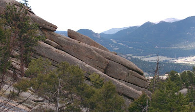
Greyrock Mountain itself is a batholith of granite. A batholith is an intrusion magma through a layer of metamorphic rock, sort of like a hernia. This one formed 1.4 billion years ago. Granite is resistant to erosion and so the Greyrock Mountain has remained intact while the surrounding substrate has drifted away.


A rainy day view climbing up Greyrock

This distant, treeless ridge looked like the perfect place for a dragon to land.

There are two trails that head towards Greyrock Mountain. They start out together, diverge at 0.64 miles, and reconvene 0.75 miles from the summit. The rightmost trail (Summit) follows a lush riparian gulch for 50% of its length before ascending up a ridge with carelessly strewn granite boulders. The leftmost trail (Meadow) starts out near a stream but quickly ascends up a series of nearly treeless switchbacks to a lofty ridge. It then descends to a long meadow with dramatic views of the Greyrock Mountain before it climbs up again to the intersection of the Summit Trail. Near the intersection are the stark remains of a forest fire. On this trip, we took the Summit Trail up and the Meadow Trail down, so be aware the photos in this post for the Meadow Trail will be in reverse order to this description.

More rocks on the ascent

The easier of the Class III scrambles. The trees in this cleft made it easy to pull oneself up.

The common trail up Greyrock Mountain is not for the faint of knee or for one-handed hikers. It ascends quickly right next to the shear face of the mountain and at times weaves dangerously close to breath sucking heights. There are obvious wooden posts to keep you near the trail, but most of it is rock scrambling at a Class II level (difficult walking, often steep with doubtful or slippery footing). Perfect training for the summer 14er season. There were two places on this trail that I would categorize as a Class III scramble (handholds and footholds must be utilized to make upward progress). I was carrying a heavy pack and on one of these, a friend needed to pull me up. Had I been alone, I could have taken off the pack and tossed it upwards and then scrambled up solo.

A view of the pond looking east

The pond looking north

The top of Greyrock Mountain is very much a surprise. From the trail below it looks very solid and very round but in fact it is a boulder field at the top and very flat in portions. Trees have grown into this area and a pond has formed. This is a very serene spot.

Burned section of the Meadow Trail

This is just part of the meadow that gives the Meadow Trail its name. That is Greyrock Mountain to the right.

The actual summit of Greyrock is at the opposite end of the edifice from where the trail comes in. Because of the rain and the slick rocks, we decided not to scramble up to the official summit. There did not seem to be any trail markers pointing the way either. This turned out to be a good choice. By the time we descended the two Class III spots it was raining in earnest, and the rocks had become very slick. On a normal Colorado day, this would not be an issue.

The upper ridge of the Meadow Trail

Mists hang over the peaks

Our trip down the Meadow Trail was almost surreal. Once past the pleasant meadow, the trail climbs up a long series of ridges. At the apex of these, we decided we were no longer in Colorado but somewhere in the UK. The rain became much heavier at this point as well, adding to the British ambiance. It seemed like it took forever to descend again to the trailhead but finally we made it. Soaked, hungry, but exhilarated none-the-less.

The Meadow Trail descends down to the saddle in the middle of this picture and then off to the left and down again. The clouds below were drifting rapidly.

Nearing the bottom of the Meadow Trail. Here the rain finally started to decrease.

The trail begins and ends at a bridge crossing the Poudre River, which was swollen with rain and snow melt. Everyone along the front range should hike Greyrock at least once. Don't take my experience for typical conditions, however. In summer, I suspect this trail would be toasty. Spring and Fall seem like optimal times. For hikers in Ft. Collins, you have no excuse. This great trail is in your back yard.

Monday, May 25, 2009

Gem Lake

Distance: 3.4 miles round trip
Elevation: 7,882 ft - 8,830 ft
Elevation Gain: 948 ft

Gem Lake is small but scenicGem Lake

Gem Lake is one of my favorite hikes in Rocky Mountain National Park. It traverses an unusual igneous rock formation called Lumpy Ridge and reminds me of my youth hiking in the Sierra Nevadas.

Example of the well-maintained trail

Looking south from the trail. To the left is Twin Sisters, behind the large hill is Estes Cone, and the snow capped peaks are Longs, Meeker, and Mount Lady Washington.

The park has changed the trail head for Gem Lake since I last hiked it in 2006. There is a new, paved trailhead (Lumpy Ridge) with a nice bathroom and sign. Both the old and new trailheads are still on Devil's Gulch Road, which is right after the Stanley Hotel (see photo on my Winter RMNP photo shoot). The old trail used to skirt private property and wander by several homes. The new trail has a more natural feel to it and starts out right next to a large igneous boulder field.

The trail crosses large rock plateaus in several spots

Angled rocks. View is looking south east.

Gem Lake is a easy trail, and I will often take new hikers on it because the views are spectacular and the rocks add interest all along the way. Typical of trails in the park, the route is well maintained although towards the end, there is a section of high steps that would trouble someone with knee issues. Most of the trail is sandy with occasional traverses of broad rock plateaus.

A flat portion of the trail

Is this natural, or created by some ancient Atlantian civilization?

Besides the towering rocks, views of Estes Park and the surround peaks are visible from several locations. These would make an ideal al fresco dining spot for those more interested in lingering over a picnic lunch.

There are young aspens along the trail.

Paul Bunyans' boot. I knew someone that scrambled up this large rock and stuck his head through it. It is larger than you think.

Gem Lake itself is more of a pond and not a very spectacular destination. It is surrounded by rocks but compared with other high alpine lakes in the park, just does have the same appeal. It really is the route itself that is the appeal of the Gem Lake trail.

Faces in the rocks

Nearing the top, the rocks grow more dramatic. This wall is to the west.

There is a feisty inhabitant of the Gem Lake area and that is the Golden-mantled Ground Squirrel (Spermophilus lateralis). On a trip back in 2004, they were everywhere and were literally climbing into people's packs, climbing up their pant legs etc., all in an attempt to gather morsels of forbidden sandwiches. On this trip we did not see any, but we did not stay at the lake for long either.

A broader view of the Estes Valley and Peaks

The rock wall to the right of the trail just before the lake

The other nice feature of Gem Lake is that it is lower in altitude than other trails so it is suitable for the late fall or early spring. For a longer hike, one can head down the back side of Lumpy Ridge to Balanced Rock. I have done this once and found the trail somewhat monotonous, but since Gem Lake is short, the added excursion will at least give you mileage.

A Golden-mantled Ground Squirrel taken in 2004. At one point this little gal climbed up into my lap.

If you are visited the park for the first time and live at sea level, I would consider doing Gem Lake as one of your first hikes. It is short, lower in altitude, and the views will give you a perspective on the more traveled southern part of the park.

Friday, May 22, 2009

Cottontail Rabbit


Spring is here and the rabbits are breeding well...like rabbits. I am seeing them on every trail, under every shrub in the neighborhood, and in the glazed eyes of my dog as it dreams on the couch. Cottontails (Sylvilagus sp.) give birth to two to six litters every year with five young'ens per litter. That is up to 30 new rabbits a year from every female. Thank goodness for carnivores!

It seems like everything preys upon the poor little rabbit including humans, which kill over 50,000 a year. For the Cottontail it seems, life is a continuous war zone. I was surprised to learn their life expectancy is only a year. No wonder they breed like crazy.

There are three species of Cottontail in Colorado and they are impossible to identify in the field. They live in the mountains, plains, and deserts.


These pictures were taken on the Bitterbrush Trail. This specimen was standing outside its burrow when a biker came up. He said he would distract it while I swooped in for a picture. It worked. Now, if I can only get my hiking partner to do the same thing with that Mountain Lion I have always wanted to capture on film.

Cottontails are herbivorous and eat a variety of grasses. They also love to munch on your just planted flowers, garden vegetables, or other important greens.

Monday, May 18, 2009

Bitterbrush Trail (Hall Ranch)

Distance: 5.5 miles round trip out of a possible 7.4 miles
Elevation: 5,499 ft to 6,179 ft
Elevation Gain: 680 ft

The mesas of Hall Ranch Open Space

I used to hike Bitterbrush a lot when I lived closer to Lyons. It has an “old west” feel to it because of the large eroded bluffs near the trailhead. It also climbs over a large formation of igneous rock, which I found particularly appealing.

The beginning of the Bitterbrush trail

On this trip however, I felt like I was trying to hike on the Los Angles freeway, there were so many mountain bikers lunging down the trail or struggling up it. It really was a distraction. I know it was a very nice day and bikers have a right to exist too, but geesh, you would think they could at least have some manners. Half the time we were not aware of the bikers until they were practically on top of us. At one point I had to leap off the trail and into a large prickly tree trunk to escape total annihilation. The bikers must have recently “discovered” this trail because in all my time hiking it, I had never seen this many.

Igneous rock in the switchback section. This area is flat, much of the area was not.

Blooming cactus on the trail

Bitterbrush is a low elevation hike, which make it suitable for the spring and fall. Right now with all the hills green, it is particularly attractive. I was amazed too how much wildlife we saw. There was tons of Mule Deer, Cottontail Rabbits, Prairie dogs, and even a juvenile Golden Eagle.


Looking west from a view point on the switchback portion
Above the switchbacks, the trail becomes a wider road through open meadows

The trail starts out near a very nice picnic facility. I have always wanted to have a group BBQ there because of the large protected tables. After a half-mile traverse of the open meadows the trail ascends a large series of switchbacks. These switchbacks are imbedded into a large igneous rock formation. At times there are nice plateaus and at other times deep ankle twisting cuts. Throughout, Ponderosa Pines scatter the hillside. There were only a few wildflowers out but you could tell more were on the way.

Vista near the intersection of the Antelope Trail

At the top of the hill, the trees fade and the trail, now much wider, skirts a hillside with expansive views to the west and north. At 2.25 miles is the junction of the Antelope Trail. Continuing drops the hiker 100 feet or so down into a meadow. This is home to the highest Prairie dog colony in Boulder County.

Deer in the meadow

We decided to head down for another half mile and ended up turning around at one of the Prairie dog interpretive signs.

Looking north from the highest point. The Antelope Trail is off to the right through the trees. There is a bench along the trail in the lower left portion of the picture.

Because it is so open, Bitterbrush makes a great winter hike. Unless we have a major dumper, there is usually little snow.

Down in the meadow heading northwest

Please note, that this is a non-doggie trail, which is another reason I have not hiked it much lately. It may also be the reason that so much wildlife was present.

Even more deer on the return back through the switchbacks. I would have thought the continual stream of bikers would have disturbed them, but they seemed non-pulsed.

Thursday, May 14, 2009

Lubahn Trail

Distance: 2.5 miles round trip (official trail), 3.0 to 3.5 miles round trip with extension depending upon your route
Elevation: 5,676 to 6,319 ft
Elevation Gain: 400 ft (official trail), 643 ft (to Castle Rock)

Fellow hikers atop Castle Rock looking towards Denver, which can be seen in the distance

No one ever hikes the Lubahn Trail by itself. Instead they use it as the primary way to get part way up South Table Mountain in Golden and then use one of the many unofficial trails to the top of Castle Rock (formally known as Table Rock). According to the city, this additional excursion is illegal because it traverses private property. Tell that to the 30 or so people on the trail the day I did it.

View of Castle Rock from the street below

Every time I visit Golden I have wondered what the view would be like from a top Castle Rock, an obvious rocky outcropping on the top of South Table Mountain. There is a lot of history behind that hunk of rock as well.

Starting out to the right

Heading up

The last pitch to the top. The dirt was very loose here.

In 1906, the Castle Rock Resort opened on top of South Table Mountain. Because the locals vehemently opposed a liquor license, it started out as a café. Tourists rode donkeys up the cliff face to sip on cappuccinos.

Past the outcroppings, the trail flattens and spreads out in all directions

By 1913, a railway had replaced the donkeys and for 25 cents a tourist could ride to the top and gamble at a casino.

Approaching Castle Rock

In the early 20’s, it became a segregated dance hall and illicit drinking establishment but business was not good and soon the KKK took over the area for their meetings. In the largest event over 1,000 Klansmen frolicked atop the mountain and a large cross burned on top of Castle Rock. Who knew sleepy Golden had such a torrid past! When the structure at the top finally burned down in 1927, few wept.

Closer now

Old stairs

Today, the journey to the top of South Table Mountain is a pleasant if brief workout. The day I climbed it, I was in quite a rush. I had just finished a Sierra Club meeting and wanted to get a jaunt in before racing home to get the dogs and take them to the dog park for their daily regiment.

View looking northeast. Coors Brewery is down in that valley. Note that Golden does not look like the pristine mountain scenery Coors uses in its advertising.

The trail is typical of Front Range trails. It was dusty, rocky, and poorly maintained in places. The Lubahn portion of the trail is a loop and I started off of Belvedere Street and headed to the right.


View to the north and parts of Golden

As the trail climbs, the views of Golden become more expansive. At the southern extent of the loop, the trail begins to switchback and heads relentlessly up to two rocky outcroppings. The official Lubahn Trail heads back to the left here but the unofficial trail heads straight up. There are no signposts, or obvious distinctions to differentiate the two. For a while Castle Rock itself disappears behind the side of the mountain. The last pitch up between the outcroppings is straight up and filled with loose dirt.

Looking down on the Lubahn Trail. I descended via this route.

Once on the top, the hiker is presented with a series of intersecting trails that head off in all directions. It is easy to find you way, however, just find the nearest trail that heads off to the left. This portion of the trail is on the wide top of South Table Mountain. It is filled with grasses and occasional small shrubs.

Looking back up at Castle Rock from the descent

There is an obvious train of folks heading to Castle Rock, which has a series of short concrete steps leading to the top. These are the remnants of the old dance hall.

Heading down and looking to the south

On the top, Castle Rock just appears to be a large rocky ledge. The views of Golden are very nice and you can look down onto Coors Brewery as well. Some leftover yokels from days gone by have graffitied the place here and there, detracting from the natural ambiance.


I hiked this trail in late March when the weather was warm and the promise of Spring was in the air.

Because I was in a rush, I headed back down and met my friends who were just arriving. They had taken the left route up the Lubahn Trail and taken the most direct social trail to the top. This would be the trail that I would take down. It was precipitous in spots and not suitable for folks with knee problems. At the bottom of this section of the Lubahn there are few interpretive signs that discuss the geology of Golden’s mesas.

North Rock Creek Snowshoe

Distance: 4 miles round trip Elevation: 9,180 ft to 9,780 ft Elevation Gain: 600 ft Dogs: Off leash until the wilderness boundary North...