Showing posts with label snowshoe. Show all posts

Saturday, January 5, 2013

Robert's Tunnel Road Snowshoe

Distance: 3 miles round trip
Elevation: 9,129 ft - 9,100 ft
Elevation Gain: 29 ft
Dogs: On leash
Bathroom at Trailhead: No
Date snowshoed: 25 December 2012

View of Buffalo Mountain and Lake Dillon from the Robert's Tunnel Road.  The pictures in this post were taken with my iPhone camera.
Near the Dillon Nature Preserve and the Keystone Ski Resort is a snowshoe/ski route that travels along the Frisco-to-Keystone bike path before splitting off onto the Robert's Tunnel Road (see image at end of post). This route is very level, great for cross-country skiing or walking and affords lovely views of Lake Dillon, Buffalo Mountain, and Peak One of the Tenmile Range.

The parking lot for this route is located across from the Dillon Cemetery and usually has a few cars in it, so it is hard to miss.

Looking back on the snowy route and the two skiers that passed us.   In late afternoon, most of this route is in the shade.
Directly across from the parking lot is a tall ridge that becomes a locals tubing resort in the winter.  There must have been 10 kids or so sliding down the slick hillside screeching with glee. Given the expense of some of the tubing facilities at the various nordic centers in the area, I am sure the parents were screeching with glee as well.  Nothing like free winter fun.

The first quarter mile of this route is on the bike path that was unfortunately plowed. Since we had on snowshoes, we ended up walking to the sides where the plow had created a small berm. Once through the gate to Robert's Tunnel Road, the route was unplowed and had about six inches of fresh power on it.  I was able to break trail the entire time, which is always fun when there is no elevation gain to get the heart rate going.

Looking northeast along the route across Dillon Bay
At around 0.8 miles is the entrance to the Dillon Nature Preserve itself. This is an open meadow leading to more naturalistic trails. Since our time was limited, we stayed on the road but it was tempting to head up hill just for the fun of it.

Our goal was the Robert's Tunnel Complex, which is rather obvious at the end of the road. The sun was setting and the wind was picking up, however, so we turned around a little early and got back to the car just as the temperatures were approaching zero. It has been a nippy holiday season so far in Summit County. Not as cold as our eye ball freezing excursion to North Tenmile Creek two years ago, but cold enough to warrant coats for the dogs and hand warmers for the humans.

The Gore Range comes into view
Next time I do this route, I think I will just wear boots.  Plenty of folks were out walking their dogs along the road and I am sure on a normal day it will be well tracked.

Satellite View of the route showing the location of the cemetery and parking lot


Sunday, February 26, 2012

Westminster Hills Snowshoe

Distance: 3 mile loop
Elevation: 5,500 ft - 5,600 ft
Elevation Gain: 100 ft
Dogs: Off leash (Run baby run!!)
Bathroom at the trailhead: No

Two feet of snow covers the wide expanse of the Westminster Hills Dog Park.  All the pictures in this post were taken blindly (due to sun glare) with the camera on my phone.
Westminster Hills is an open space dog park near the Broomfield Airport.  I take Ginger, the hyper one, there at least 4 days a weeks because she can roam over the entire 400 + acres of prairie while I run the trails.  After the February 2012 dumper (24 inches and counting), the park was transformed into rolling hills of crystalline beauty.  I grabbed a pair of showshoes and left the normal trails to bushwhack in a fit of childish glee.  What is it about breaking the rules that feels so naughty?  As you can sense, I don't allow myself to do that often.

Route taken.  If you zoom in on the map you can see the dotted outline of some of the trails.  They have greatly expanded in the last few years.
The well tracked entrance to the park
Looking south to the southern plateau.  You can sense the snow depth.
Heading south to the top of the southern plateau.  This segment was along an official trail.
On the southern plateau looking southwest towards the hills
The open space consists of a large meadow bordered on either side by plateaus that rise around 100 feet higher than the surrounding area.  A gully travels between the two into a distant and deep field transected by power lines.  You can loop the meadow,  go "up the gut", take either of the plateau routes, head to the "back 40" or any combination of these.  When I run, I can loop around and get in 4 miles.  On this trip I ignored these established routes and tried to find the deepest snow.  The route turned out to be around 3 miles according to the GPS on my phone.

The trail across the southern plateau is around 0.75 miles long.  That is the Boulder Flatirons in the distance.
At the far end of the "Back 40"
Walking along the edge of the northern plateau where the snow was deepest
Heading back down to the trailhead.  The trail "up the gut" is slightly visible on the hillside to the right.
A giant cottonwood borders a small pond that fills with water in the spring.  Water loving dogs romp there with their owners.

Saturday, February 4, 2012

Buffalo Cabin Snowshoe

Distance: 3 miles round trip
Elevation: 9,760 ft - 10,619 ft
Elevation Gain: 700 ft
Date Hiked: 15 January 2012
Dogs off leash:  Until Eagles Nest Wilderness Boundary
Bathroom at trailhead: No

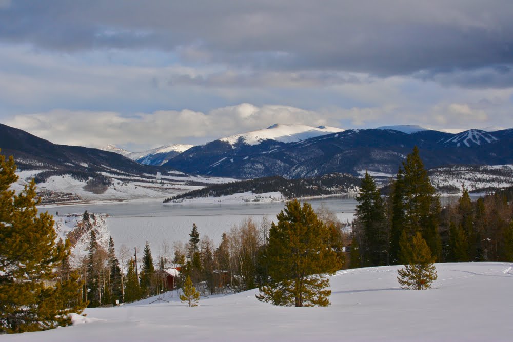
The view of Lake Dillon, the Continental Divide and the condos of Wildernest from 700 ft up Buffalo Mountain
Buffalo Mountain (12,777 ft) is the large as in very large as in immensely large round mountain you see after jetting down from the Eisenhower Tunnel heading west.  Climbing Buffalo Mountain (3 miles/3,017 ft elevation gain) is one of the steepest ascents around but snowshoeing 1/3 of the way to the summit to the ruins of Buffalo Cabin is something mere mortals can do.   While devoid of views unless you press on for at least another 0.2 miles, it is very popular with the locals.  This is in fact why I was on this trail.  I wanted something close by to exercise both the dog and myself on a Sunday afternoon.

Standing at the trailhead and looking at the parking lot.  The trail to Lilly Pad Lake is just around the bend.
The trailhead
The route starts at the Buffalo Cabin Trailhead, 3.5 miles up Ryan Gulch Road (one of two main roads that shoots straight up the mountain's slopes).   Note this road starts out as Wildernest Road lower down.  This trailhead shares a parking lot with Lilly Pad Lake, which you can also access from Frisco.

Playing with the shadows on the snow.
The route is easy to follow if a bit monotonous.  You pass the Wilderness Boundary at 0.36 miles and come to a 4-way junction at 0.6 miles.  Go straight to intersect the Gore Range Trail and South Willow Falls, go right to dead end at the end of the other road that goes up the mountain, and go left to continue climbing.

Typical trail segment.  Packed snow in the trees
There are actually several ruins of cabins along the way but it can be hard to tell in the snow.  The first one appears around 0.95 miles while the official (e.g. largest) one occurs shortly thereafter at 1.1 miles.  All that remains of these cabins are a few logs piled on top of each other.

Trail sign at the 4-way junction
I had snowshoed this trail before but it had been 9 years ago and my memory was very foggy.   I do remember reaching a point where I could not go any further and this trip was no exception.  On this trip, I was in microspikes and reached the point where the angle of the trail became very steep.  Snowshoes and poles would have been required to go any further.   I snapped a few photographs of the views and headed back down.  This spot is only a few tenths of a mile beyond Buffalo Cabin, but it is up and around another switchback.

The ruins of Buffalo Cabin.  With all the downed trees it is hard to tell what is a tree and what is a cabin log.
Buffalo Mountain was so named because it reminded the early settlers of the large hump of a buffalo.  There are two prominent avalanche shoots that the grace the eastern side.  These slid in 1986 and 2003.  The large cirque that is also one of the prime identifying feature was carved by glaciers.

The view at the turn around point
I would not send tourists on this trail since there are so many more scenic options in the area, but for general exercise this trail will get your heart pumping and burn off last night's fried chicken wings.  Sometimes that is all you want.

Saturday, January 28, 2012

Pennsylvania Gulch Snowshoe

Distance: 5 miles round trip
Elevation: 10,400 ft - 11,105 ft
Elevation Gain: 705 ft
Date Hiked: 14 January 2012
Dogs: Off Leash
Bathroom at Trailhead: No
Tags: #snowshoe, #breckenridge, #coloradooutdoors

Pacific Peak (13,950 ft), Unamed Peak, Crystal Peak (13,852 ft) (barely visible), and Peak Ten (13,633 ft) dominate the view of Pennsylvania Gulch.
Pennsylvania Gulch is a lesser known but scenic snowshoe south of the Breckenridge Ski Resort in the hamlet of Blue River. It is known mostly to locals who use it extensively. Snowmobiles are allowed on the road but did not bother us at all.

You get to the trailhead by traveling 3.4 miles past the last Breckenridge traffic light and then turning left onto the Blue River Road. Proceed about 0.2 miles then turn bear right on Royal Drive. Bear right at the junction. Proceed about 0.2 miles then turn right on Regal Circle. Proceed about 0.1 miles. Turn right on Coronet Drive. Travel on Coronet Drive about 0.6 miles. The trailhead is by the information kiosk.

Map showing the location of the trailhead and the general route. 
The trailhead
Ruins of an old cabin less than 0.5 miles up the trail
The route follows Pennsylvania Creek up a eastward traveling gulch.  It starts out in the trees and heads steadily uphill for the first 0.5 miles. After that it levels out and comes to nice wide open expanse at 1.0 miles. This broad meadow filled with willows peaking out of fluffy snow mounds made the trip worth while. The views back down the valley were stunning as well with Pacific Peak and Peak 10 dominating the western horizon.

Typical early trail segment...in the trees
Breaking out into the meadow at 1.2 miles.  You can see the route on the left in the distance.
The only people we met were two cross-country skiers who turned around after the large meadow once the trail returned to the trees at 1.75 miles. We decided to continue and after another half mile in the trees we came to another open area and decided to continue to its end before turning around. This brought us to the spot at 2.5 miles where the trail crosses the creek. Along the way we crossed two other trails. Trail 6113A at 2.0 miles took off to the left while 113A at 2.35 miles crossed the creek and ascended into the trees on the right.

Whipped cream and willows grace Pennsylvania Creek
Looking west towards the Tenmile Range
There as been so little snow in Summit County this year, that I having been wearing microspikes everywhere instead of snowshoes.  This trail was no different, but since I had never done it before I wore snowshoes just in case.  They weren't necessary.  It is amazing how sore your hips feel after 3 hours in snowshoes.  The wider stance stretches muscles that aren't used very much.  I was glad when we turned around and headed back down.

The rocks on the area are high in iron and have a pleasing red tint.
Where the trail crosses Pennsylvania Creek...our turn around point
Pennsylvania Gulch is a pleasant outing that is suitable for beginners and skiers who like wide trails and a gentle slope (e.g. no head meet tree introductions).  I would take others there just to see the views of Tenmile Range.

Saturday, February 12, 2011

Old Dillon Reservoir Snowshoe

Distance: 1.5 miles round trip
Elevation: 9,066 ft - 9,193 ft
Elevation Gain: 127 ft
Dogs: Off Leash
Tags: #snowshoe, #lakedillon, #summitcounty, #coloradooutdoors
Buffalo Mountain seen from the trail around the Old Dillon Reservoir near Frisco CO. 
The trail to the Old Dillon Reservoir near Frisco CO is a short excursion to the top of a ridge with stunning views of Lake Dillion and all the peaks that surround the lake. In winter the shores of Lake Dillon are covered with snow and a hush seems to have fallen over the area because the outdoor enthusiasts have abandoned the water for the ski slopes.

Map showing the Trailhead location and general route
The trailhead for this snowshoe is located off of the Dillon Dam Road just north of the Heaton Campground. There is no signage for the parking lot, which can be easily missed. The Forest Service has recently culled many of the beetle kill trees around the parking lot, making the area look empty and torn up. It is rare to see more than two cars in the parking lot.
A snowy Lake Dillon
The route switchbacks up the hillside through Lodgepole Pine and Aspen, with plenty of open areas with views of the lake. In 2014, the Old Dillon Reservoir itself was completely redone and it is much easier to circumnavigate the area. This area is windy, which can mean large drifts on the south side of the ridge.
Looking back across the reservoir

Saturday, January 22, 2011

Treeline Loop Snowshoe

Distance: 3 miles round trip
Elevation: 10, 407 ft
Elevation Gain: 630 ft (cumulative)

Typical Segment of the inner portion of both the Treeline Loop and Powerhound Loop

The Treeline Loop on Tennessee Pass near Leadville and Ski Cooper is not the most exciting trail but it sure is popular. Exceptionally well marked, blue diamonds and large wooden signs guide cross-country skiers and snowshoers through the loop options, which is good, because otherwise it would be very easy to get lost.

The Treeline Loop starts in the trees past the bathroom and comes out just out of view to the left of the photo.

The route starts on Tennessee Pass in a large parking lot directly across from the entrance to Ski Cooper. For this parking lot there are 4 possible routes. The Treeline Loop and the Powderhound Loop are the shortest and together form a very mushed numeral 8. The middle portion of the 8 is the same for both loops.

The first trail marker. Both the Treeline Loop and Powderhound share the inner portion.

You can take either loop in any direction, but we chose to start at the western end of parking lot. This segment is coincident with the Continental Divide Trail and a sign within 50 yards lists mileages to Copper Mountain Ski Resort to the north (23 miles), and Hagerman Tunnel (see summer hike to that area) to the south (14.9 miles). Shortly beyond this is another sign showing the turn for the Powderhound Loop continuing up the Continental Divide Trail and both the Treeline Loop and Powderhound heading up the middle. This is the direction we chose.

Coming into the open meadow at the top of the ridgeline

The initial portion of the trail is totally in the trees and winds east and west as the trees permit. This is the first trail I have been on where there was a separate track for skiers and snowshoers. I found this particularly tedious because the two tracks interwove continuously so we were constantly trudging back and forth.

The trail sign at the end of the middle portion (at 1.34 miles)

After 400 ft or so of elevation gain we came to the top of the ridge. Here there were a few open meadows but still no views. There were so many tracks that it took us a while to find a blue diamond and our route. Don't let the meadow bushwhacks fool you, there is another wooden trail sign at the apex of the 8 (at 1.34 miles) and you should persist along the ridge until you come to it.

There are a few more open areas on the lower portion of the Treeline Loop, but not many.
Our original intent had been to do the Powderhound Loop, but we were frankly so bored with the area that we wanted out of there as quickly as possible and so chose to head left on the shorter Treeline Loop.

The junction with the Continental Divide Trail (at 1.92 miles) indicating the Treeline Loop heading left. The back side of this sign says "Colorado Trail" and points to the right from this angle.

From this point the trail heads sharply downward through yet more trees until it reaches the other side of the Continental Divide Trail. This junction at 1.92 miles is also marked with a wooden sign. From this intersection the Treeline Loop heads left and back up to the parking area.

Don't get excited by this "peek-a-boo". It lasted for a couple of seconds and was the only one we saw.

Anyone who has read this blog for any length of time knows I don't like being in the trees. Whether hiking or snowshoeing I like the wide-open view. Having done the Bemrose Ski Circus off of Hoosier Pass near the Breckenridge Ski Resort the day prior, this trail seemed like a snore-fest. Don't let my jaded attitudes prevent you from trying it however. It is ideal for novices since it is relatively flat and well marked and it would be ideal on a day when the nefarious Leadville winds are blowing. If you are in the area and want something more challenging with better views, check out Vance's Cabin, the Lower Mosquito Pass Road or my all time favorite Mayflower Gulch near Copper Mountain.

Saturday, January 15, 2011

Mesa Cortina Snowshoe

Distance: 3 miles round trip
Elevation: 8,824 ft - 9,473 ft
Elevation Gain: 649 ft net (790 cumulative)
Bathroom at Trailhead: No
Dogs: Off leash until wilderness boundary (0.9 miles)
Tags: #snowshoe, #silverthorne, #coloradooutdoors

View from the Mesa Cortina Trail of family frolics 
The Mesa Cortina Trail is a popular trail in Silverthorne CO that in summer can be used as an after work doggie outing or connector trail to South Willow Falls. In winter, it makes for a pleasing snowshoe because it alternates between deep forest and open meadows.

The initial part of the trail travels through Aspens.
The trailhead is located in a residential area of Buffalo Mountain. There is a parking lot but no bathroom.
Looking back towards Lake Dillon from one of the early meadows
Shortly after the trailhead, the trail narrows and winds downwards through thick Fir trees covered in thick globs of snow. Protected and dark, I suspect this snow stays on the trees all winter. The only thing missing from this winter tableau was a Starbucks kiosk selling eggnog lattes.
The narrow Fir-laden part of the trail
Below this section is one of my favorite local meadows. The official route stays on the upper side with views of the Williams Fork Range, but the steep slopes and piles of snow are inviting and many a track attest to those who chose to frolic in the open.
Crossing another meadow
Beyond the meadow, the route begins a steep climb through a stand of mostly dead Lodgepole Pines. Stark and lonely, this segment will at least get your heart rate up.
Looking towards the Williams Fork Range
While in summer, I have traveled the entire length of the trail, in winter, I usually go out after work when time is limited and will stop after the trail levels out and begins its shift back towards the north. If you have plenty of time, you can continue all the way to the intersection with the Gore Range Trail. The scenery won't change much, though if you do.
Heading up hill into the trees. This segment is steeper than it looks.

North Rock Creek Snowshoe

Distance: 4 miles round trip Elevation: 9,180 ft to 9,780 ft Elevation Gain: 600 ft Dogs: Off leash until the wilderness boundary North...