Showing posts with label Vail. Show all posts

Sunday, January 7, 2018

North Trail Snowshoe (Red Sandstone Road West)

Distance: 4 miles round trip
Elevation: 8,240 ft - 9,040 ft
Elevation Gain: 800 ft (net) 919 ft (cumulative)
Bathroom at Trailhead: No
Dogs: On leash but many off
Tags: #snowshoe, #winter, #coloradooutdoors, #vail

A typical segment on the North Trail...this time looking back to the east and a hillside covered with Aspens. 
North Trail, across the valley from the Vail Ski Resort, is 11.5 miles long but with parking lots interspersed every 3 to 4 miles, you can easily break it up into segments.  On this trip we started at the parking lot on Red Sandstone Road and headed west.

Map of the entire North Trail
Trailhead
In all honesty we did not even know that this trail existed until we decided to try and snowshoe up Red Sandstone Road out of Vail. In looking at the trail map we noticed North Creek and ended stopping at the trailhead on our way up just out of curiosity. When we discovered that Red Sandstone Road was 100% snowmobiles, as evidenced by the caravan of trucks and trailers parked all along the road, we decided to try the North Trail instead.

Looking south on an early switchback 
Looking at Red Sandstone Road and Vail 
This segment of the North Trail switchbacks and switchbacks up the north side of Vail Valley in an seemingly endless procession. In fact the switchbacks are really only about a mile and the views of Vail are rather revealing. At 1.5 miles the trail entered a beautiful and extensive Aspen Grove (fall hike anyone?) that is deep within a quiet crenelation further from the noise of I-70.  For a short hike this would make a suitable destination although there was no place to sit down. We decided to continue for another half mile to see where the trail led and ended up eating lunch on a nice log protruding from the snow with views of Mt. Holy Cross to the south and the Gore Range to the east.

The view from an upper switchback
Looking back to the east.  Note the narrow trail and steep hillside. 
It was obvious from the well packed trail that this route is popular with the locals. Because of the steepness, and narrowness of the route, we wore our Microspikes, which had all the grip we needed.  Do not attempt this trail without some sort of gripping footwear or you will slide down the hillside faster than a gold-medal winning toboggan team!

The Aspen Grove at 1.5 miles
The view of the Gore Range from our lunch spot at 2.0 miles
While not a wilderness experience, this trail was fun and practically balmy on a sunny day. We saw only two people the entire time.  I will have to check this trail out in the fall.  Note that the trail is closed from April 15th - June 15th for wildlife preservation.

Below is a shameless ad for the Microspikes we wore on this trip.  They really are a winter essential.

Monday, March 27, 2017

Lionshead Rock (aka Cougar Trail)

Distance: 4.5 miles round trip
Elevation: 8,005 ft - 9,463 ft
Elevation Gain: 1,458 ft
Dogs: Off leash
Bathroom at Trailhead: No
Tags: #coloradooutdoors, #hiking, #minturn, #vail
Nearby hikes: Game CreekTwo Elks Recreation Trail

The view from the Lionshead Rock near Minturn, CO
Lionshead Rock in Minturn, CO is a local icon and a quick jaunt to this dramatic promontory is a great way to boost the blood flow to brain while getting fido out at the same time. While the route is mostly in the trees, the views at the end of the Mt. of the Holy Cross and surrounding valleys is worth the wait.

Heading into the Aspen Grove
Lionshead shares the first half mile with the Game Creek Trail, and the initial sign only mentions Game Creek. Both start out next to a home and quickly climb uphill to a small shelf skirting private property. Strings of rope and surveyors tape admonish the hiker to stay way from their land. Once past this property, the trail dips back down to the valley floor and crosses the creek at a small bridge. The route then stays on the left side of the creek until the junction with the "Cougar Trail", located on the other side of the creek. It is this trail that takes you to Lionshead Rock. There is no bridge over the creek and in the spring run off this can be a raging torrent.

A softer trail segment
The remainder of the trails switchbacks up through the trees. At one point is passes around a large Aspen grove that is filled with brim in the spring with wild raspberry bushes. At 1.0 miles is a small overlook and shortly thereafter the trail turns sharply eastward and heads dramatically and painfully upwards for almost half a mile. This segment is both unrelenting and very rocky but cardiovascular distress is what makes Lionshead so popular, so dig out the defibrillator and take it at a jog. At 1.9 miles is a second overlook while the rock itself is at 2.25 miles.

Lionshead is part of a larger escarpment that is all slowly eroding
While the trail continues beyond the rock, you'll recognize the destination without difficulty. A short spur trail heads slightly downwards and then upwards onto a broad flat plateau suspended in the air above Minturn. Be advised that a large chunk of this rock broke off in 2014 so use caution while venturing outwards. Eventually mother nature will claim the entire promontory in her perpetual desire for a new look through the geological equivalent of a lift and tuck (mountain building and erosion for those who like to impress their friends with scientific jargon).

The spur trail to the rock itself
If you don't mind the extra weight, Lionshead rock is a great spot for an afternoon libation combined with gourmet snacks. The adjacent hillsides are filled with Aspens and the wind always seems to blow sweetly, if sometimes a tad forcefully. As a bonus, the route down is not technically difficult in case your decide to consume all your provisions to save the weight on the way down.

You get to the Lionshead Trail from Hwy 24 in Minturn, which is just south of I-70 and just west of Vail. As you enter Minturn, look for bridge to the left as 24 merges into Main Street. Take this left turn and pass north of the large Saloon. Just past the Saloon is Rail Rd. Turn right here and then left on Taylor Road. This dead ends nears some homes. You will probably see one or two cars parked in a small parking area to the left. The trailhead itself is up a short (100 yard) spur that travels between the houses. A small wooden sign marks the start. Note this is the same trailhead for Game Creek. Lionshead splits of a half a mile up the trail.


Monday, August 15, 2016

Two Elks National Recreation Trail - West Entrance

Distance: 5 miles round trip
Elevation: 8,140 ft - 8,839 ft
Elevation Gain: 699 (net), 980 ft (cumulative)
Bathroom at Trailhead: No
Dogs: Off leash
Caveats: Trail is closed after the first two miles May 1st to July 1st for Elk calving. There is a shooting range a quarter mile from the trailhead, which can be noisy.
Date Hiked: 3 July 2014
Tags: #hiking, #coloradooutdoors
Nearby hikes: Game Creek


Mount of the Holy Cross is visible from the Two Elks National Recreation Trail.
The Two Elks National Recreation Trail (NRT) near Vail Colorado is a 12 mile "short cut" between I-70 and Vail proper and Highway 24 south of Minturn. Going the entire length requires serious stamina, a car shuttle, or a mountain bike. On this trip, we were looking for a less rocky trail with minimal elevation gain since my hiking partner had broken her arm several weeks before and falling on it would not have been good despite the new hardware screwed into her bone. Two Elks turned out to be just perfect.

The parking area
The trail starts out on shaded side of the creek.
From the west side near Minturn, this trail ascends gradually along a soft dirt trail that parallels Two Elk Creek. The vegetation was so lush that I felt half-naked without a pith helmet and machete. The gulch through which the creek travels is surprisingly deep, and the trail weaves up and down, sometimes close to the water but often as not half-way up the hillside. This turned out to be problematic because the weather was hot and we wanted to dunk our bandanas in the stream to cool off. Even in places where the trail was at the level of the creek, it would have been a "Doctor Livingston I presume..." adventure to bushwhack the 10 feet to the stream.

Two Elk Creek is ever present but not always accessible.
Now on the sunny side of the creek
Because the gulch is oriented east/west, the vegetation is quite different depending upon which side of the creek you are on. The southern/north-facing side is filled with Douglas Fir and other shade-loving plants, while the northern/south-facing side is more open, filled with Aspen, green grasses and the occasional wildflower.

The trail alternates between treeless hillsides and thick foliage.
One of the more rare steeper segments
The higher you ascend, and on this trip we did not go that far, the better the views back down the valley. The famous Mount of the Holy Cross (14,009 ft) is framed nicely by the towering trees although the angle is just slightly off and the cross itself looks crooked.

Thick carpets of Boulder Raspberry covered the trail.
The most voluminous plant in the area was the Boulder Raspberry (Oreobatus deliciosus) otherwise known as Mountain Plover. While yellow in the fall, this plant is verdant green in the summer with white, ostentatious flowers. Individual plants can grow 3-5 ft tall and 6 ft wide and I think every single one of them had, they were so thick. This trail must be bear heaven in the fall in the with all the berries.

Another picture of the creek.
I have seen pictures of the trail much further up the gulch than we made it. The trees disappear and green grasses dominate. In our case, we turned around at 2.5 miles (851 ft cumulative gain) in a very pleasant stand of Aspen.

Boulder Raspberry encroach on the trail.
The Two Elks Trail is a find that I will add to my early season hiking list. In July it was too hot, but I bet in late May or June it would be sublime. Be advised, because of its length, you are more likely to run into mountain bikers than hikers. The ones we did run into were generally courteous and were NOT racing down the narrow track like they were being chased by wolves. A novelty to be sure!

The pleasant glade of Aspens that was our turn around point. Because of the thick undergrowth, there were not many places to sit.
To get to the west entrance of the Two Elks Trail from Vail, take I-70 west to exit 171 (Hwy 24) and head south. Go approximately 2.7 miles to Minturn and Cemetery Road (marked with just a typical green street sign). Turn left and cross the bridge.  Follow Cemetery Road until it crosses the railroad tracks (you'll see the cemetery at that point).  From the cemetery, continue on the road and turn right at the first fork (a single lane dirt road...rough put passible with a low clearance 2WD) and left at the second fork. You'll be weaving up and down the hillside paralleling the railroad tracks. Just before the trailhead, you pass a series of shooting ranges. They were occupied, and we did hear gun fire for the first half mile or so of the hike despite the roaring sound of the Two Elk Creek.

Saturday, August 2, 2014

Upper Piney River

Distance: 6.4 miles round trip
Elevation: 9,350 ft - 9,910 ft
Elevation Gain: 851 ft (cumulative)
Bathroom at the Trailhead: Port-o-lets
Dogs: On leash, Eagles Nest Wilderness
Date Hiked: 13 July 2014

Cow Parsley along the side of Piney Lake on the Upper Piney Lake Trail.
Upper Piney River Trail in the Eagle's Nest Wilderness out of Vail has views that will make you hyperventilate. The route starts at Piney Lake, one of the highest lakes in Colorado you can drive to, and heads towards the Gore Range's "Grand Traverse", a series of jagged peaks reminiscent of Wyoming's Grand Tetons. Getting to the trailhead, however, is an hour-long journey (at 10 mph) up bumpy dirt road, passable, but not fun, in a 2WD vehicle.

Parking lot at the Piney River Ranch. The trail starts at the lake.
The start of the trail
To get to the Piney Lake, take exit 176 off of west bound I-70 to the frontage road, then turn right onto Red Sandstone Road. A short distance up Red Sandstone, and at a hair pin turn, Forest Service Road (FSR) 700 splits off to the left. This intersection is disconcerting because the paved road whips to the right and the dirt road is straight across. What you don't know, because you come up too fast, is that there is a stop sign for cars coming down Red Sandstone Rd so it is safe to cross. FSR 700 is a long and rocky dirt road that will make you wonder where on earth you are heading. It twists and turns, goes up and down, and splits in several locations. At every intersection is a sign pointing the way to Piney River Ranch, located at the lake, so you should not get lost. At 6.7 miles you'll pass the trailhead to Lost Lake, another nice hike in the area.

Past the lake the valley becomes a verdant marsh.
Fairy trumpets along the trail
Once you get to the Piney Lake there are two parking lots. The one closest to the lake is technically on private property. Since we spent half of our inheritance on some cold drinks after the hike, I did not mind using the lot.

Entering the Aspens
The trail leaves the valley floor and winds up the left side with views of the rocks ahead.
The trail starts right at the lake and heads along the shoreline. At 0.4 miles you enter the Eagle Nest Wilderness. Take a moment to gasp at the view.  Once past the lake, the trail looks down on a verdant marsh. Upper Piney River winds lazily in one continuous S-curve down the valley. Just looking at that peaceful setting made we want to slow down, take deep breaths, and sigh. Isn't it amazing how much effect water has our psyche? 

Looking down on the marsh as the trail begins to ascend
Getting close to the end of the valley
Also in this area is the Marmot gauntlet. There were large boulders overlooking the marsh every 20 yards. Each one had a Marmot family on it with you-tube cute youngsters peaking out from every crevice. Check out these baby Marmots from the American Basin Trail.

After the trail shifts to the right, the terrain is filled with large boulders.
The falls that is the destination of this hike
At 1.0 miles the trail starts to leave the valley and head into the trees. From this point onwards, the trail winds in and out of Aspens as the valley narrows toward a rock wall. At 1.4 miles the trail starts to gain altitude in a series of switchbacks. You know you are getting close when the trail turns sharply to the right at the back of the valley.

At 3.2 miles the trail appears to dead end into a flowing cascade. Follow the social trails to the right to a series of boulder overlooking the torrent. Supposedly an indistinct trail continues for another 4 miles to Upper Piney Lake.

Looking back down the valley near the falls
I have been wanting to do this trail for the last 4 years, ever since we popped up to Piney Lake after hiking to nearby Lost Lake. I had to wait until my dog was old and calm enough to keep on a leash...still not easy! You may not have the restriction, so hold on to your fillings and brave FSR 700, the views are worth it and so much more!

Saturday, March 31, 2012

Betty Ford Alpine Garden

The naturalist setting of the Betty Ford Alpine Garden in Vail
The Betty Ford Alpine Garden near the ski resort of Vail, Colorado is a lovely place for an early morning or late afternoon stroll. Not interested in climbing Mt. Flora to see Moss Champion, a ground hugging tundra flower, you can do so at the garden with Fifi or an aged P in tow.  If you are of the fur coat, Lexus-with-a-bow set then lunch in Vail and you will have an outing.

The garden gift shop
The entrance to the Garden.  Like most great things in Colorado there is no entrance fee!
Trees, flowers and winding paths.  Each route reveals something new.
There are four main gardens constructed between 1989 and 2002.  Don't expect to see just Colorado flowers, however.  The garden have collected alpine and high-altitude plants from around the world.  Visitors can wander between the Mountain Perennial Garden, the serene Mountain Meditation Garden, the Alpine Rock Garden, and the latest Children's Garden.

Columbine actually comes in many colors.
Another path
This could be a shot of manicured path in Rocky Mountain National Park
I confess that botanical gardens can be overly neat for my tastes.  I once went on a vacation to Vancouver Island Canada and visited the Butchart Gardens.  The formality, rigidity and never ending structure of that garden were a harsh contrast to the wild, chaotic, moss-coated old growth forests north of the city.  The Alpine Garden has some of that and you won't think for a moment you are ogling the wildflowers on Shrine Mountain, but the organizers have done a good job of adding waterfalls, rough hewn steps, and large shrubs of I'll-grow-as-I-please Columbine...enough to give visiting New York socialites a  Disneyland-ish taste of wild Colorado.

Ok Alpine curators, what is this flower?
An American Red Squirrel was chattering away in the tree above this bench but declined to have his picture taken.
One of the many water accents
The garden is located at exit 176 in Vail near the Ford Amphitheater.  Follow the frontage road east  to a large parking lot near some baseball fields and tennis courts (Ford Park).  Follow the path that leads to the amphitheater, go past its entrance until you see a small green cottage.  The entrance to the garden will be on the right.

Several artistic tree trunks watch over visitors.
Looks like another type of Columbine
So, if you are in Vail or just passing through, stop for a moment for a breath of fresh mountain air and a dose of vibrant color at the Betty Ford Alpine Garden.  You will learn something about the unique adaptations plants make to high-altitude while soothing the soul.  If you are a hiker like me, remember that returning to civilization every once in a while is a good thing, so take a shower, put on something besides sweat stained hiking pants, and use the gardens as a means of easing yourself back into the real world.  It will be less jarring than the traffic through the Eisenhower tunnel!

Wednesday, July 21, 2010

Piney Lake


Tags: #mountainlake, #coloradooutdoors, #hiking, #canoeing, #gearguide
Hikes: Upper Piney RiverLost Lake
Critters: Marmot

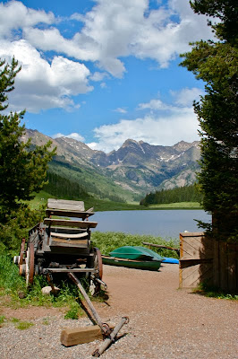
Scenic Piney Lake
Piney Lake, near Vail, Colorado is one of the highest lakes in the state that you can drive to. There are several trails that leave from the area including Lost Lake which is on the way, and Upper Piney River, which leaves from the parking lot of the Piney River Ranch, a commercial outfitter at the lake. The outfitter has a limited restaurant (no ice cream!!), lodging, and canoe rentals for around $20/hour.

Is this not a classic Colorado tableau?
Piney Lake is accessed 12 miles BEYOND THE END of Red Mountain Road on the north side of I-70 in Vail. The route is over a rough dirt road that is passable in a passenger car if you go slow. It will take at least a 40 minutes if not more to get there depending on road conditions.

Directions: From I-70, take Exit 176 for Vail. Take the North Frontage Road west to Red Sandstone Road. Turn north here and follow the paved road about 0.7 miles to a fork with a dirt road on the left. There should be a Forest Service sign indicating this is Red Sandstone Road #700 (Reset your odometer here). Continue up this road about 2.7 miles to an intersection with the Lost Lake Road (#786) and continue left. At mile 6.5 you will pass Red and White Mtn Road-FSR 734. At mile 6.7 you will pass the Lost Lake Trail parking lot on the right and then reach an intersection where the Muddy Pass/Moniger Road goes left. Stay right here. (Some maps show the Red Sandstone Road changing number from FSR 700 to FSR 701 at this point, and some don’t, but regardless, you stay right to get to Piney Lake and the Upper Piney River Trail). At mile 9.1, you will cross the Piney River and see a trailhead for Lower Piney River Trail - FDT 1885 on the left. Stay right and reach a Forest Service parking lot on the right at mile 10.65 before the entrance to Piney River Ranch.

The outfitter

North Rock Creek Snowshoe

Distance: 4 miles round trip Elevation: 9,180 ft to 9,780 ft Elevation Gain: 600 ft Dogs: Off leash until the wilderness boundary North...