Thursday, June 17, 2021

Old Man's Whiskers

Old Man's Whisker (Geum triflorum pursh), also known as Praire Smoke or Long Plumed Purple Avens, grows in large colonies in moist to dry woodland areas. While mostly a prairie flower, it has been growing en masse in the high country this year (2015). It starts out as a pod that hangs downward, but when in full bloom, turns upwards emitting a thousand tentacles.

Early stage of Old Man's Whiskers
The whiskers start to appear.
Tentacles anyone?

Tuesday, July 10, 2018

The Wave

Distance: 5.5 miles round trip
Elevation: 4,875 ft - 5,200 ft
Elevation Gain: 325 ft (net) 730 ft (cumulative)
Bathroom at Trailhead: Yes, with emergency water
Dogs: Off leash, but NO water
Special Permit Required: Daily lottery

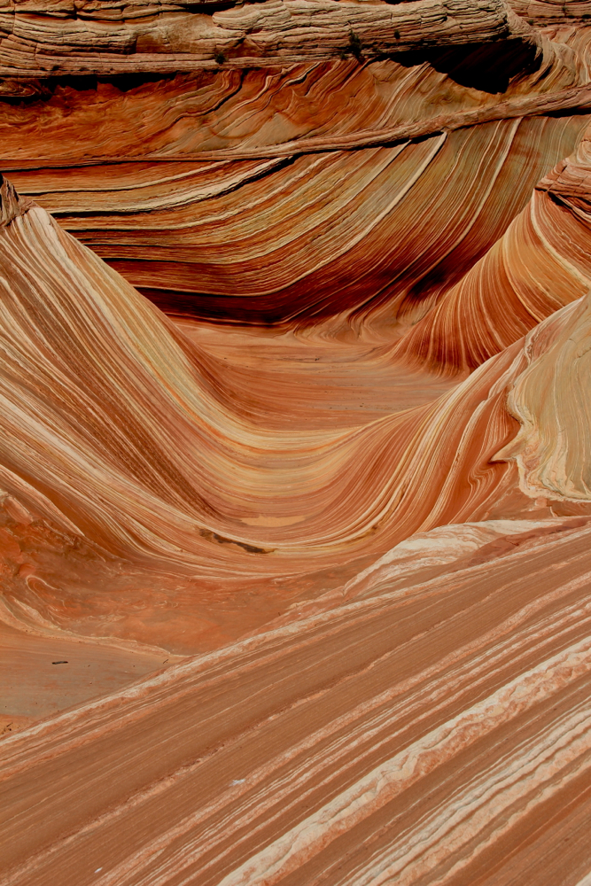
The Wave is one of the most sought after destinations in the American Southwest. That divot on the right side is purported to be a dinosaur "slide".
A hike to THE WAVE in northern Arizona's Paria Canyon/Vermillion Cliffs Wilderness is an improbable and totally unforgettable journey to one of the most photographed places in the American West. You can't just go there, however, you have to win a daily lottery (official link on how to enter) for one of the 10 walk-in or 10 online slots allowed each day. People try for years and never get in. We won two walk-in slots on our second try.

Parking area
Heading up the wash into Buckskin Gulch
The walk-in lottery is held at the Bureau of Land Management (BLM) visitor's center in Kanab, Utah every morning between 0900 and 0930. You show up before the lottery, fill out a permit request, and then hang out with 100 or more other hopeful souls while bingo balls twirl enticingly in a bin. Everyone's attention is glued to that wheel. Around and around, the numbers of destiny whirl.

Turn off, now marked with a sign
Looking east after cresting the first hill
Having done this a million times, the rangers know how to work the anxious crowd. They told tales of past winners, all of whom had good karma going for them. They helped others fill out their forms. They did not lock anyone in the bathroom. They were just driving by. They did not bring any permit money. Ennui, nonchalance, and "I won't win" are the attitudes that allow the stars to align. The probability of winning is so low that winners often need respiratory assistance.

Heading towards the saddle
Looking northeast from the saddle. It is barren country.
The exhilaration of winning is quickly over because immediately thereafter the rangers provide an unnerving "come to Jesus" lecture about how unlikely it is you will ever return from the Wave. They look you in the eye, assess your abilities, and pointedly ask..."will I be having to find and drag your desiccated carcass out of back country tomorrow?" Most lie and say "Oh No!" Like anyone is going to give up their once in a life time spot!

Why the drama? The route to the Wave is over terrain most never experience. It is vast, barren, hot, disorienting, and downright deadly under certain conditions. Additionally, the Rangers see people with little or no hiking or desert experience. Even experienced hikers can get lost in the seemingly endless rock formations that lead to the Wave. There was one near and two actual fatalities in 2013. This promoted that installation of a few signs.

Most of the route is across rock.
The rangers do provide a brochure showing the route with pictures but emphasize that getting back is not easy even with pictures and the new signs. If you have a GPS, bring it. If you have a map and compass, bring that too. If you have neither, consider hiring a guide in Kanab.  It was true, getting back was not easy and we had a GPS track to follow. The terrain looks the same in all directions.

Heading towards the Twin Buttes
The trailhead to The Wave is located down House Rock Valley Road (BLM Road 1065), which can be accessed from the north 38 miles out of Kanab, Utah or from the south 13.5 miles out of Jacob Lake, Arizona. Unless it has recently rained, the northern route is preferred. While this road is passable with a passenger car, having a 4x4 will increase your chances of getting there. Only a little rain can turn the road into a harrowing luge run.

Towering sand dunes
The trailhead for the Wave also serves Buckskin Gulch, which is a good alternative outing if you don't win the lottery. The route crosses the road and then enters the river bed that is the entrance to the gulch.  0.5 miles up, the route leaves the river bed and ascends a small rocky hill. From there the route travels across a wide, shrub covered valley. Directly ahead is the sandstone ridge that is so difficult to cross on the return trip. The small saddle that marks the best crossing point is very obvious from this side but not so obvious from the other.

Walking across this rock is like being grilled to death.
After crossing the saddle, the route is sloped and filled with conical hoodoos, the remnants of prehistoric sand dunes. Route finding is necessary since there are no cairns and only a couple of recently added signs that get easily lost from view.

Looking down into the final sand-filled valley. The Wave is up the cliff straight ahead.
Eventually, the route leaves the firm sandstone and descends into a broad sandy valley dotted with the occasional Cottonwood. The Wave is located across this valley and up the cliff face beyond. It is quite the sandy scramble to get into the entrance to the Wave and there is no best way to approach it. The occasional zigzag, upwards lunge, and sandy slide are all required.

Inside the Wave
The entrance to the Wave is like entering a canyon. The walls tower on either side and unique striated rock patterns begin immediately. The famous photograph of the Wave is taken after walking through the entrance, through the Wave itself and up a rock amphitheater on the other side. It is not uncommon to see a queue of people lining up to take pictures with some hogging the interior. After seeing this, I understood why BLM limits the number of daily permits to twenty total (10 online, 10 walk-in).

Looking down on the Wave from just slightly above
While the Wave itself is otherworldly and incredibly photogenic, there are other areas in and around that should be explored. Fossilized dinosaur tracks have been recorded on the way to and near the Wave and scenic vistas abound.

The Wave is actually just part of a series of large dunes.
Morning is the best time to photograph the Wave, since it is still in shadow.  This is a good thing since the hike is a dry, hot affair even at 50 degrees. All that rock retains heat and radiates it back to the foolish mammals that dare to walk where only "thunder lizards" have walked before. I can't image what it would feel like at 100 degrees. No one should take this hike lightly.

The exit to the west, which leads to some stellar views.
One of the rangers expressed their amazement at how much allure the Wave holds for people. She thought there were prettier, more remote places on Earth, but none seem to hold the mystic of the Wave. It is included in most screen savers or nature calendars. It is profiled in travel magazines and listed amongst the 500 places you should visit before you die.

Standing outside the Wave proper to the west.
I think the BLM has created half of this mystic with their visitor restrictions. There is something about human nature that drives us to want what only a few can have. The other half of the mystic comes from visitors who return from the Wave with pictures that race around social media and the internet.

Hiking above the Wave. The colors change to a lighter yellow.
Personally, I was mesmerized by sitting in the warm cocoon of the Wave's smooth solidity. It was like being snuggled by Mother Nature while being dazzled by color and pattern. The size and age of the Earth are hard to grasp. Sitting in one small place where so long ago the same sun had warmed the same sand, made it all seem so much more tangible. Who knows. It was if nothing else wickedly cool!

Water often collects in pockets around the area.
*********************
Proposed Lottery Changes (July 2015):

The BLM has issued a draft business plan containing changes to the Coyote Buttes permit system. Permits for ten people per day would be issued via an on-line semi-annual lottery. One lottery would be held on December 1st for the months of January-June, and one on June 1st for July-December. Lottery applications would be accepted during the two months prior to the lottery date. The semi annual lottery would go live for the July-December 2016 period. The walk-in lottery would be replaced by an on-line lottery held two days in advance of the permit date. Permit for ten people per day would be issued via this two day lottery. The two day lottery would go live March 15, 2016. This will fundamentally change the user experience.

Saturday, March 31, 2018

Cub Lake

Distance: 5 miles round trip
Elevation: 8,120 ft - 8,625 ft
Elevation Gain: 503 ft (net), 640 ft (cumulative)
Bathroom at Trailhead: No
Dogs: No (National Park)
Date Hiked: 21 July 2012

Cub Lake in Rocky Mountain National Park is known for its Lily Pads
Cub Lake is a short but scenic hike in the middle of Rocky Mountain National Park.  It is popular because it is lower in elevation, has minimal elevation gain, and ends at a sleepy mountain lake filled with Lilly Pads and waterfowl.

Trailhead
Standing on the bridge looking at the Big Thompson River
I ended up on this trail recently because a friend from Florida came into town and I needed an easy, close to Denver, hike.  Originally, I was going to take her to Dream Lake, but on this date Bear Lake Road was under construction and getting into the park was an exercise in herd dynamics and getting to Bear Lake Trailhead with a couple hundred of my "closest friends" was more than I could stomach.  The bus to Cub Lake was practically empty.   Even when RMNP is not under construction, this pattern holds.  Cub Lake, while far from empty, will be significantly less crowded than other places in the park. 

Early trail segment through scrub and Ponderosa Pine
Looking out into Moraine Park
To get to Cub Lake turn off of Bear Lake Road on to Moraine Park Rd (dirt passable by a passenger car) and head west.  You'll pass the Moraine Park Campground entrance before reaching the trailhead for.  There is only parking here for a dozen or so cars so be advised.

The trail turns westward and slowly begins to climb
Closer to the lake, the flora changes to Spruce, fern and Aspen. 
The trail heads north and crosses the Big Thompson River on a nice metal bridge.  In this dry year, the river was barely flowing, but that did not stop families with small children from frolicing in the water.  After the bridge, the trail weaves in and out of some interesting rock formations along the western edge of Moraine Park, a large grass filled meadow that dominates this part of the park.  In the fall this meadow will be filled with a flash mob of elk dancing in their annual rite of species renewal.

After around 1.7 miles, the trail becomes steeper, rockier, and more shaded. 
Aspens and ferns make lingering on this segment pleasant,  particularly on a hot summer day. 
In half a mile the trail winds around to the right and heads westward.  A less than obvious junction with the South Lateral Moraine Trail, which heads back towards Bear Lake Rd, also marks the general area. From this point on, the trail slowly gains altitude as it skirts the edge of a ridge overlooking a small valley filled with ponds, lush brush, Aspen, and Spruce and Fir.

You won't be alone at Cub Lake
Yellow flower from the Water Lily (Nuphar polysepala).  This plant has large green leaves that float on top of the water of shallow, muddy ponds.  
Around 1.7 miles, the trail becomes much steeper as it ascends the final pitch to the lake. This segment is rocky but shaded by numerous Aspen that would make this trail lovely in the fall.  At just past two miles is a spur to a backcountry camp.  The lake itself comes into view at 2.5 miles.

The author, foreground, and her friend Christine sunbath on their very own rock at Cub Lake.
We observed this Garter Snake (Thamnophis elegans) swim from leaf to leaf.  While a common terrestial inhabitant of the park, I did not know they also enjoyed the water. 
Long and narrow, Cub Lake is covered in Lily Pads and there were at least 5 species of ducks that were cruising the southern shore. Along the northern shore is a series of large boulders and small clumps of people were perched, marmot-like, on each one. The cacophony of chatter was at times unnerving but in the park, you have to get used to your fellow humans.

Clouds reflected in the lake
We lingered on our rock for quite a while and several female Mallards came cruising by within inches of us, totally unaffected by our presence.  After a while we got back on the trail and headed an additional 0.2 miles to a higher lookout that provides a great view of the lake from above.

Heading upwards for a view of the lake from above
Looking down on the lake
If interested the hiker can continue heading west until the trail intersects with the Fern Lake Trail another 2 miles, and considerable elevation gain, further on.  From that junction the hiker can either return to the trailhead via trail/road or take another deter to Fern Lake itself.

Map of the area showing the flat Moraine Meadow and Cub Lake 
It has been years since I have hiked to Cub Lake and I was surprised at how inviting the experience was.  The numerous people we passed was a slight deterrent, but the scenery and ease of access easily compensated for it.

Sunday, January 7, 2018

North Trail Snowshoe (Red Sandstone Road West)

Distance: 4 miles round trip
Elevation: 8,240 ft - 9,040 ft
Elevation Gain: 800 ft (net) 919 ft (cumulative)
Bathroom at Trailhead: No
Dogs: On leash but many off
Tags: #snowshoe, #winter, #coloradooutdoors, #vail

A typical segment on the North Trail...this time looking back to the east and a hillside covered with Aspens. 
North Trail, across the valley from the Vail Ski Resort, is 11.5 miles long but with parking lots interspersed every 3 to 4 miles, you can easily break it up into segments.  On this trip we started at the parking lot on Red Sandstone Road and headed west.

Map of the entire North Trail
Trailhead
In all honesty we did not even know that this trail existed until we decided to try and snowshoe up Red Sandstone Road out of Vail. In looking at the trail map we noticed North Creek and ended stopping at the trailhead on our way up just out of curiosity. When we discovered that Red Sandstone Road was 100% snowmobiles, as evidenced by the caravan of trucks and trailers parked all along the road, we decided to try the North Trail instead.

Looking south on an early switchback 
Looking at Red Sandstone Road and Vail 
This segment of the North Trail switchbacks and switchbacks up the north side of Vail Valley in an seemingly endless procession. In fact the switchbacks are really only about a mile and the views of Vail are rather revealing. At 1.5 miles the trail entered a beautiful and extensive Aspen Grove (fall hike anyone?) that is deep within a quiet crenelation further from the noise of I-70.  For a short hike this would make a suitable destination although there was no place to sit down. We decided to continue for another half mile to see where the trail led and ended up eating lunch on a nice log protruding from the snow with views of Mt. Holy Cross to the south and the Gore Range to the east.

The view from an upper switchback
Looking back to the east.  Note the narrow trail and steep hillside. 
It was obvious from the well packed trail that this route is popular with the locals. Because of the steepness, and narrowness of the route, we wore our Microspikes, which had all the grip we needed.  Do not attempt this trail without some sort of gripping footwear or you will slide down the hillside faster than a gold-medal winning toboggan team!

The Aspen Grove at 1.5 miles
The view of the Gore Range from our lunch spot at 2.0 miles
While not a wilderness experience, this trail was fun and practically balmy on a sunny day. We saw only two people the entire time.  I will have to check this trail out in the fall.  Note that the trail is closed from April 15th - June 15th for wildlife preservation.

Below is a shameless ad for the Microspikes we wore on this trip.  They really are a winter essential.

Friday, December 15, 2017

Lily Lake

Distance: 0.9 mile loop
Elevation: 8,930 ft
Elevation Gain: none
Bathroom at Trailhead: Yes
Dogs: No, National Park
Date Hiked: 7 July 2013

Lilly Lake in Rocky Mountain National Park is a short 0.9 mile stroll around a beautiful mountain lake that is suitable for older parents or small children
Lily Lake with Mt. Meeker, Long's Peak, and Estes Cone in the background 
Lily Lake on the outskirts of Rocky Mountain National Park is a handicapped accessible stroll filled with views of Long's Peak, Estes Cone, and Twin Sisters. Suitable for families and older folks, I took my parents there and was agog at the baby ducklings, swooping Peregrine Falcons, and fluffy blue clouds. Just lovely.

Looking up at Lily Ridge, which is not in the park. There is a 1.7 mile trail that ascends the ridge.
Golden-mantled Ground Squirrels are always willing to pose for the camera. Just don't feed them!
While Lily Lake won't get your heart rate up, it will put you in a contemplate mood. From the numerous oil painters lining the shore and fishermen floating on their pontoons, it was obvious that others felt the same way.

Blanketflower (Gaillardia aristata) along the trail
A log bench allows for repose along route. Twins sisters soars in the background. 
You get to Lily Lake from Highway 7 at the Twin Sisters Trailhead. There is a small parking lot at the lake itself and a larger one for Twin Sisters across the street. Cars whip by at bone crunching speed so be careful crossing the road. We arrived at 10:00 am and a half a hour later both lots and all the slots along the road were filled. Who were these people? Lilly Lake is not exactly in the main part of the park.

The smooth, gravel trail is suitable for all abilities.
These Mallard ducklings were a hit as they drifted near the shore.
One of the many painters we saw.

North Rock Creek Snowshoe

Distance: 4 miles round trip Elevation: 9,180 ft to 9,780 ft Elevation Gain: 600 ft Dogs: Off leash until the wilderness boundary North...