Saturday, October 26, 2013

Ice Lakes

Distance: 8 miles round trip
Elevation: 9,850 ft - 12,270 ft
Elevation Gain: 2,420 ft (net) 2,736 ft (cumulative)
Dogs: Off leash
Bathroom at the trailhead: Yes
Date Hiked: 27 Aug, 2013

Glacier ground rock causes Ice Lake near Silverton Colorado to be so blue.
Surreal Ice Lake near Silverton Colorado is mind-blowing in a good way. 
Ice Lakes near Silverton CO is one of THE premier hikes in the state. Not only is the destination an otherworldly cerulean blue lake nestled beneath towering spires, but the journey itself will take you up several shelves filled with water falls, majestic pines, and dramatic boulder fields. If you are traveling to Colorado to hike, this should be at the top of your list.

Looking up to the first shelf from the trailhead. 
Standing on a small spur trail looking at the upper falls. The trail crosses what turned out to be Clear Creek on some rickety logs far below and then switch-backed up to this point. It looks like the trail use to cross here, but I would stick to the new trail and not chance the dilapidated construction. 
The trailhead to Ice Lakes starts at the far end of South Mineral Campground. You get there by taking highway 550 north from Silverton for two miles and then county road 7 for 4 miles. While the route to the campground is well marked, there is no signage at the trailhead. If you find yourself continuing up a rough 4x4 road off into the trees, you will have gone to far. The trailhead is actually in a large parking lot across located across from the bathrooms. We missed it because it was empty and looked like just another part of the campground.

Crossing some of the rock rivulets on the first shelf
The route leaves the upper shelf through a series of steep switchbacks that wander in and out of stands of Spruce and Fir Trees. 
Even though the elevation gain on this hike was close to a hefty 3,000 ft, the trail was so soft and the switchbacks so continuous, that I practically glided upwards. The only confusing moment came around 1.0 miles near the upper segment of a large water fall that the trail laboriously skirts. Near the top of the falls the trails begins to descend again and heads off in a totally different direction. Since we did not know where the lake was in relation to the various cliffs visible from below we wondered if we were meant to take one of the many social trails around the falls.

The first view, at 2.6 miles, of the second shelf. Ice Lake is on the next shelf. 
Walking through the fall color to base of the second shelf
A half a mile from the upper falls, the trail breaks out into a wide sloping meadow below the first set of cliffs. Rivulets of rock cascade down from above and the route crosses these several times as it inches upwards. Don't worry about the imposing vertical barrier ahead. The trail will sidle off to the left and enter the trees where a few tenths of a mile and a hard pounding assent will take you up to the next shelf.

The second shelf is surrounded on three sides by vertical cliffs dripping with waterfalls. 
Looking up at some old mine tailings. 
The stroll across this middle shelf was a journey to a Coloradan Shangri-La. Despite the fall color, the air was humid and the ambience tropical. Had we passed through a wormhole that had transported us to Hawaii? There were waterfalls cascading down all three sides of the amphitheater-like bowl and water was clinging to our shoes deposited there from the overgrown shrubbery. I did not want to leave this unusual place but my friends had already bolted ahead towards the final pitch (at 3.3 miles, 11,500 ft) so I gamely began to climb the cliff face near a large waterfall on the left.

We got quite wet crossing this stream to get to the base of the second shelf. If you follow the stream into the meadow a bit there are a couple of places you can jump over with little difficulty. 
Heading up the wall of the second shelf. The route will go close to the waterfall on the left.
We did run into some mid-westerners who had turned around at this point claiming the exposure and terror of this segment drove them whimpering backwards. With some trepidation I began to ascend the well defined but steadily upwards-sloping route at the base of the bowl. Within two tenths of a mile the route did indeed get rocky but it was at least ten to fifteen yards wide and only required the most modest of bracing on the uneven terrain. Unless you have never stepped off the sidewalk in your life this portion will be a piece of cake.

Looking down on the route from half-way up the wall of the second shelf
The easy trail to the third shelf
From this point on, the route traverses horizontally across the face of the bowl as it weaves in and out of the steadily diminishing shrubbery. There is still a ways to go once you reach the upper shelf, but you will sense the lake is near and hasten your step for that final view.

Oh and what a view it is. Ice Lake is a geologic marvel. Its startling color looks more like a fancy liqueur than a mountain tarn. The blue comes from "rock-flour", superfine ground up rock produced by glaciers. When the glaciers that used to exist there melted, they deposited this material in the lake itself. This rock is so small that it remains suspended in the water instead of sinking to the bottom. These particles absorb the reds, yellows, and oranges in sunlight allowing only the blues to be reflected back to the eye. Ice Lake is seriously and totally blue. The kind of "did I toke too much?" sort of mind-blowing blue. Wow is all I can say.

Once you reach the third shelf, the lake is still a ways away. 
After sitting awhile, my brain cells popping in awe like overheated popcorn, I wandered off to the left where a short distance takes you to a small, alas boringly green, tarn further up the shelf. This is pleasant though because you get better views of the eroded spires that frame the lakes. You can continue another half mile to Fuller Lake but after 4 plus miles I was not in the mood to wander all over planet. I wanted another fix of Ice Lake.

Ice Lake...ahhhhh
To the right of the Lake is another trail that heads up and around the cliff face to Island Lake that apparently has a small round outcropping smack in the middle of it. We did not go there either but several other hikers did. Apparently it is worth the extra effort.

Small but scenic Upper Ice Lake

Saturday, October 5, 2013

Spud Lake

Distance: 3 miles round trip
Elevation: 9,438 ft - 9,824 ft
Elevation Gain: 380 ft
Bathroom at Trailhead: No
Dogs: Off leash
Date Hiked: 26 August, 2013

Quiet Spud Lake
Spud Lake is a small scenic lake between Durango and Silverton Colorado. It is mentioned in the 100 Classic Hikes book as a great place to bring a family. Just note that the family needs to have a high-clearance 4x4 because West Lime Creek Road, which connects Highway 550 to Spud Lake has deteriorated badly. The road is not a technical 4x4, but it is a very rocky one. A sedan would bottom out quickly.

These cliffs appear on West Lime Creek Road just before the Trailhead. That meadow is part of Scout "Lake"
The Lilly Pads on what is left of Scout "Lake"
The two wooden posts marking the trail. You can't see these from the road.
Finding the trailhead to Spud Lake is also tricky. We were coming from the south while looking at a map that flipped north and south and so was expecting the trailhead to be on the right instead of the left. Let me set the record straight. When driving north on West Lime Creek Rd (Forest Road 591), the first clue is Scout Lake on the right-hand side of the road. Be advised...maps makes Scout Lake look much larger than it is. It is really more of a Lilly Pad covered pond quickly turning into a meadow. Just past this milestone (at roughly 3 miles) the road turns to the right and heads up hill. There was an ATV parked at this curve, which gave us a clue. We parked and looked around. There was a social trail heading west and a larger jeep road heading north. 20 yards up the jeep road were two vertical wooden posts sticking out of the road to block traffic. This was the marker in the book that indicated the trail. Still, it was not until we met a backpacker on the way down did we feel comfortable that we had found the right spot. There is no signage at all in the area and it feels pretty remote.

Heading up through Aspens
The trail is not devoid of vistas.
The trail to Spud Lake is not difficult and winds pleasantly through Aspen, interesting rock formations, and past numerous Beaver ponds. I confess I was tired on this trip, however. We had hiked West Lime Creek earlier in the day and I was hot and thirsty by the time we reached the lake. Given the isolation and easy access to the water, I decided to go for a swim. This turned out to be the highlight of the day. Unlike many mountain tarns, Spud Lake is not ice-cold and makes for a thoroughly refreshing dip.

One of the many Beaver ponds that exist on cascading shelves.
This sandy "beach" provides gradual access to the water and may be why the 100 Classic Hikes author thought the lake was ideal for small children. I don't have kids, but I am not sure that is a sufficient draw.
These interesting peaks border the eastern end of the lake.
The lake itself is surround by high cliffs and Fir trees. There are plenty of places to fish and lounge and after the first five minutes had the place to ourselves. If you are in the area, and can get to the trailhead, it would be a nice way to spend an afternoon.

Saturday, September 28, 2013

Fall in the Rockies

2013 is an unprecedented year for reds
Fall has finally arrived in Summit County. Now is the time to get out and wallow in the cooler temps, blazing blue skies and red-toned Aspens.

The Lilly Pad Lake Trail (Frisco Side) is a great Aspen walk. Another great trail to try near Silverthorne is the Ptarmigan Trail.

Sunday, September 22, 2013

West Lime Creek

Distance: 4 miles round trip (out of 6 miles possible)
Elevation: 10,000 ft - 10,306 ft
Elevation Gain: 695 ft (cumulative)
Bathroom at Trailhead: No
Dogs: Off leash
Date Hiked: 26 August 2013

West Lime Creek near Silverton Colorado
West Lime Creek in the middle of a San Juan rainstorm is like journeying to the Pacific Northwest. It is wet, primeval, and filled with VW-sized mushrooms. Most of the route traverses the drainage half way up the slope so there are lovely views of the creek below.  On this trip, heavy clouds obscured the peaks in the distance but added to the otherworldly ambiance.

The "10,000 ft" sign indicating where to park.  You won't see this driving from Silverton because of the angle and its location up the slope.
Starting down into the drainage
Initial trail segment
The start of West Lime Creek is located at a sharp swtichback approximately 10 miles south of Silverton Colorado on Highway 550 at a small two-car sized pull off. Even though there is a small green sign with the word's "10,000 ft" that marks the spot, the sign is perched 20 feet above the road and easily missed. As it was there was a car in the middle of pull off with a "gentleman" peeing by the side of the road, all this anatomy exposed for world to see. We were so busy commenting on the bestial nature of some men that we raced by the spot not realizing we had passed the "trailhead".


One of several waterfalls along the route
Crossing the creek
This specimen of Rameria largentil, a yellow "coral" mushroom was found near the creek crossing. While some consider it edible, it is known for its powerful laxative effects.
The trail descends 50 feet or so from the road and the levels out, traversing grass-covered hillsides or stands of Spruce and Fir. At 0.5 miles is small waterfall that can only be seen by grabbing onto trees and hanging percariously over the highly eroded bank.  A few tenths of a mile further on, the trail crosses the stream above the waterfall. A large red arrow painted on a rock by the edge leads the way.

Crossing an open meadow
I took another shot of this Amantia muscaria mushroom with my sunglasses perched easily on top. Witches brew anyone?

This unnamed point at 12,200 ft is visible from several points along the trail.
The San Juans are a wetter mountain range than others in the state and the flora proves it. We came across clumps of Coral Fungi, their bright yellow colonies standing out against all the greenery. Freakishly malevolent Amanita muscaria toadstools covered the forest floor tempting the unwary to lick their poisoness slime. They are easy to identify with their bright red tops, white stems, and white dots. Pine needles covered the trail creating a soft and welcoming journey.

Much of the route in the forest was damp and dripping.  No surprise given the weather, but the flora indicates it is wet much of the time.
This is a close as you can get to this waterfall.

Close up with a zoom lens
We chose West Lime Creek as a way to get some exercise on an other wise very rainy day when hiking above treeline is otherwise not recommended. We wanted to try several smaller hikes and only went 2 miles up the drainage while 3 miles is possible. Right around 2 miles the trails starts to drift to the west opening up views of the Twin Sisters, two rounded 13ers that dominate the skyline.

As the trails curves to the west, the Twin Sisters, two 13,000 ft peaks come into view. The Colorado Trail travels along the ridge ahead, just about treeline.
West Lime Creek is a fascinating trail that anyone visiting Silverton will want to put on their list. It can be done as a break between the harder and more famous Ice Lakes and Highland/Mary Lakes or as a worthwhile destination in its own right.

Sunday, September 15, 2013

Mohawk Lakes

Distance: 6.4 miles round trip (lower lake), 7 miles round trip (upper lake)
Elevation: 10,400 ft - 11,825 ft (lower lake)/12,100 ft (upper lake)
Elevation Gain: 1,700 ft (upper lake)
Bathroom at Trailhead: No
Dogs: Off leash
Date Hiked: 10 August 2013

Lovely Lower Mohawk Lake is a popular destination near Breckenridge, CO
Serene Lower Mohawk Lake near Breckenridge Colorado
Mohawk Lakes near Breckenridge Colorado is the most crowded trail I have ever been on. The hordes at a Justin Beiber concert were nothing compared to the bridal parties, backpackers, and children in Keds that covered every nook and cranny of the route. At times you had to turn side ways just to pass.

The parking lot looking up the road towards the 4x4 parking lot, another 2 miles further on
Start of the Spruce Creek Trail
This makes no sense to me, because while the lakes themselves are just lovely, the first two miles of the route are either up a very rocky 4x4 road or through a dank, mosquito infested forest. The only thing I can figure is that every hotel in Breckenridge must advertise Mohawk Lakes as THE must do hike in the area. If it were me, I would send them to Black Powder Pass or Crystal Lake off of Hoosier Pass. They are much easier on the paws for hiking novitiates and stunning to boot.

Typical segment in the trees. On this trip it was muddy, humid, and filled with mosquitoes.
While I have the means of skipping those first two miles, I foolishly chose to do the entire hike (up through the trees, down via the road) because I needed the extra exercise. Never again. I would rather run a marathon first and then do that segment.

Where the Spruce Creek Trail intersects the end of the road
Follow the road around the bend
The trail then heads back into the trees at this small sign.
You get to Mohawk Lakes via the Spruce Creek Trailhead located 2.6 miles south of Breckenridge via Spruce Creek Road. While the parking lot is large, all those tourists have to park someplace and the cars were extended far down the road. If you don't have a 4x4, take the route through the trees. It starts at the trail sign on the left. If you do have a 4x4, you can continue onwards. There are many places to park along the way but few at the very top. Get there early if you want a coveted spot.

The most intact cabin you will pass
Looking back down the valley to the east
1.6 miles up the Spruce Creek Trail is the turn off for the Wheeler Trail, which will take you to Frances cabin, one of the local backcountry huts. After two miles, the route through the trees dumps you at the upper parking area near a water control building. Hop onto the road and follow it for 30 yards until it bends to the left. There the trail reenters the trees.

The start of the wall
This part of the route winds in and out of the trees, traversing a few small meadows before passing as the turn off to Mayflower Lake at 2.4 miles and the ruins of an ancient cabin a little further on.

One of the many switchbacks on the final climb to the lower lake. There were about 11 people sitting along the trail on the left.
After a few more switchbacks, the route starts to climb up a wall with a dramatic waterfall on the right. There are numerous places to side track to the falls or admire the views back down the valley. This wall is steep, 500 feet in 0.5 miles, and you find yourself huffing and puffing not to mention cursing as you ascend. On more than one occasion I felt tempted to take my boot and just kick folks off the mountain side. Tourist dollars be damned! Some of these folks had no business extricating themselves from the hotel pool.

Looking down on the waterfall, which is actually quite long and continues for quite a distance down-slope.
Someone created this attractive cairn overlooking the valley.
Once on top, the trail levels out at a dramatic mining ruining (3.0 miles 1,257 ft gain) with cables and a large wheel. The route then follows the outlet from Lower Mohawk Lake, traversing flat rocks until the lake itself comes into view (at 3.2 miles and 11,825 ft).

The mining ruin viewed from a hundred yards closer to the lake
Outlet from the lake
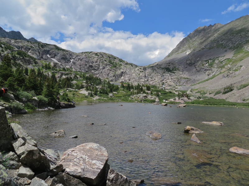
Shallow Lower Mohawk Lake
Lower Mohawk Lake reminds me a lot of Mills Lake in Rocky Mountain National Park. It is broad, flat, filled with rocks, and bordered by twisted trees. To the west a large shelf rises sharply. The left side of this shelf contains the upper lake, which is deeper in both color and topography.  I really like Lower Mohawk Lake, however.  It is different from many of the other alpine tarns I have visited. The shallow waters, elongated shape, and broad rocks along the shore are conducive to heavy navel gazing.

Heading up to the upper lake
Upper Mohawk Lake comes into view at eye height.
Looking down on Upper Mohawk Lake
Upper Mohawk Lake is a short half mile and 300 ft further up the trail to the left. While the lake itself is not as lovely as Lower Mohawk Lake, I get into serious arguments with friends about this, the approach is really fun. The views downward make the shelf really stand out and the final two steps to the lake occur at eye height...you literally come up under the lake. The walls around the upper lake are tall with lots of places to sit and admire the view.

Looking down on Lower Mohawk Lake
So the key to enjoying Mohawk Lakes is to avoid the crowds by going in the early spring when the trail is partially obscured by snow or in the fall after the children have returned to school. For varieties sake, we took the road back down, but that is just as long and is very rocky. Neither route, the road nor the trees offers much in the way of redeeming value. Sometimes life is just that way, you have to endure the mundane for the sake of the sublime.

North Rock Creek Snowshoe

Distance: 4 miles round trip Elevation: 9,180 ft to 9,780 ft Elevation Gain: 600 ft Dogs: Off leash until the wilderness boundary North...