Saturday, August 18, 2012

Carolyn Holmberg Preserve at Rock Creek Farm (Stearns Lake)

Distance: 3.6 miles round trip
Elevation: 5,276 ft
Elevation Gain: Nominal
Date Hiked: 8 July 2012
Bathroom at Trailhead: Yes
Dogs: On leash (Boulder County Open Space)
Tags: #lake, #bcos, #stearnslake

Looking at Stearns Lake in the Carolyn Holmberg Open Space
The Carolyn Holmburg Perserve at Rock Creek Farm is a small Boulder County Open Space located north of Broomfield on Highway 287.  It is popular with fishermen and locals taking strolls with their kids and dogs.  Located in the middle farm land, it is very pleasant in the spring and fall and is usually snow free in the winter.

Trailhead with parking and picnic enclosure
Starting out on the Mary Miller Trail
I chose a steamy day in July 2012 (can you say record heat anyone?) to try running the trails in the park so I grabbed my cell phone to track my pace and distance as well to take pictures on the fly. If the pictures in the post don't seem up to snuff, that is why.  In the humid air, my phone was like a wet bar of soap

Farmland stretches off to the right.  The lake is on the left behind the berm.
The route leaves the lake (out of frame to the left) and heads off to the east.
There are several named trails in the area, but the logical route is to leave the parking lot and head due west along the shore of Stearns Lake.  Technially, this is the Mary Miller Trail, but that name is not evident as you leave the parking area. As you head east, you may see Canada Goose, which frequent the Cottonwood-lined shoreline.

The road leading due east that intersects the trail.  The directional sign is on the post to the right.
Close up of the directional sign.  The arrows point down the road.  I am not sure this is how they want people to go.  If you avoid this turn you come to another trail sign further up the road.
On the far eastern side of the lake there is a large gate and dirt road that continues directly eastward.  Attached to the right-hand post of the gate is a trail sign with two arrows.  This sign was just loosely attached with some wire and was twisted in such a way that the arrows were pointing down the road.  This is NOT correct.  While you can take this road, it may be private so when you come to this junction, continue northward until you see a large trail sign pointing to the right.

If you keep going this is the sign that point to to the trail as it forks eastward.
Looking back towards the lake near several interpretive signs.  Farmland is on either side.
From this point of the route, the trail heads eastward along a slight ridge looking down on a working farm.  I chose to turn around when the dirt trail turned to pavement as it connected to a bike path heading under Highway 287.

My turn around point.  This is where the gravel path becomes paved and travels under Highway 287.  Note the farm buildings in the distance.
Back near the trailhead, this is the sign pointing to the Cradleboard Trail, which from this angle heads off to the right.
After running back around the lake, I took a left on the Cradleboard Trail, which heads due south before more curving westward.  The Cradleboard trail comes to a junction at a dirt road.  To return to the parking lot, turn right.

A typical segment of the Cradleboard Trail.  The Flatirons can be seen in the far distance.
The junction where the Cradleboard Trail continues southwest and a dirt road wraps around to the north to return to the parking lot.
One of things I love about Colorado is that "parks" are more often open space rather than green grass and manicured deciduous trees.  The Carolyn Holmberb Preserve is a perfect example.  While not large, it is perfect for a short run, afternoon stroll, or picnic at the shelter in the parking area.

The parking is ahead in the distance
Map of the trail system.  The dirt road is marked with a dotted line.


Saturday, August 4, 2012

Butler Gulch

Distance: 6 miles round trip
Elevation: 10, 546 ft - 11,963 ft (at the Jean Mine)
Elevation Gain: 1,238 ft
Date Hiked: 14 July 2012
Dogs: Off leash, National Forest
Bathroom at Trailhead: No

Mountain Views on the Butler Gulch Trail
Butler Gulch,  near the large switchback on the way to Berthoud Pass, is a close-to-Denver alpine journey filled with wildflowers, waterfalls, historic mining ruins, and make-me-move-here scenic views. This trail is fantastic!

The parking area is just the road by a gate
While most of the route follows an old road, it  occasionally gets soggy
Columbine near the trail
Another stream crossing
You get to Butler Gulch by first turning off of Highway 40 at County Road 202 and then heading due west towards the Henderson Mine. Just before the mine, a dirt frontage road splits off and parallels the paved road.  Continue on this dirt road until the parking area right at the junction with the Jones Pass Road.  Park along the side of the road by a large gate.

Monkshead along the trail
The waterfall at 1.5 miles
Indian Paintbrush along the trail
Mosses extend like beach sand from the "forest" of this riparian ecosystem
The lower sections of Butler Gulch are soggy and tree shrouded with several stream crossings and numerous stands of wildflowers. As the trail rises, it comes to a long cascading waterfall at 1.5 miles and finally breaks out of treeline at 1.8 miles. From this point on, the trail travels westward across a wide alpine shelf and finally reaches the remains of the Jean Mine at 2.7 miles.

View to the west as the trail breaks out of the trees
Heading across the shelf to the mine
The Continental Divide to the north
More flowers because I could not resist
Wildflowers dot as well as carpet this high altitude play land and I found myself irresistibly drawn to them as our group continued on their way. I would scurry to catch up only to be distracted by the latest colorful bauble.

From the western end of the shelf looking back at the Continental Divide
Getting closer to the mine
The mine tailing come into view
The ruins of the Jean Mine are interesting as well.  Purists may be offended by the piles of metal, old cars, and defunct machinery that covers the area, but this is our Colorado history and it has been part of the landscape for good or evil for the last 100 years.

Playing with an old car
More ruins
Behind the mine and wrapping around the entire area is the Continental Divide.  There is also a small spur trail leading to a shelf that formally contained a small glacial tarn.

Near the mining ruins was a whole field of Indian Paintbrush
When you see clouds like this above treeline, you should run away!  
If you are from the Denver area and are trying to decide whether to petal peep at Diamond Lake in the Indian Peaks Wilderness or on Butler Gulch, choose the latter.  It will be significantly less crowed and may actually have more wildflowers.


Wednesday, August 1, 2012

Ptarmigan

A White-tailed Ptarmigan (Lagopus leucura) munches on Bistwort in the meadows below Handies Peak in the San Juan Mountains
Numerous lakes, trails, coffee shops, and ski runs have been named for this elusive member of the Grouse family that lives exclusively in the alpine zone.  I have only seen it twice in Colorado. Once was on Mt. Sniktau and the other was on the way to Handies Peak. Their elusiveness may have nothing to do with scarcity but more to do with their superb camouflage.

Compare the rock with the plumage of the Ptarmigan.  At a distance, would you be  able to see them?
In winter they are totally white, while in summer they are a specked brown. Once I realized I was in a flock of them,  I started looking around and they were everywhere but I had to squint and stare to see them against the talus. They eat everything from alpine wildflowers to the twigs of willows. The young start out eating insects and then move on to more tastier fare.

This Ptarmigan still has a little be of white on its underbelly.  These birds are supposed to keep their white tails.  Perhaps this is a juvenile. 
Superbly adapted to the cold, this bird had feathers on its feet and around its nostrils to keep both regions warm. Just thinking about it makes me want to get a pair of down booties!


Saturday, July 28, 2012

Handies Peak from American Basin

Distance: 5.5 miles round trip
Elevation: 11,600 ft - 14,058 ft
Elevation Gain: 2,500 ft (net), 2,553 ft (cumulative)
Date Hiked: 16 July, 2012
Bathroom at Trailhead: No
Dogs: Off leash

View from the Summit of Handies Peak
The view from the summit of Handies Peak (14,058 ft)
Handies Peak is a Colorado 14er surrounded by jagged and imposing ridges forged in the fiery belly of a long forgotten volcano and finished in the frozen grip of glaciers.  It is considered by many to be the prettiest 14er, particularly via the American Basin route, which is known for its wildflowers and open meadows.  After completing this climb, I can truthfully say that this is an alpine experience par excellence.  It will leave you awe struck ... if only you can get there!

The wide and flat parking area at the far end of American Basin
American Basin is one of the most scenic areas of Colorado
Sunlight kisses American Basin.  That tongue of rock in the distance is a rock glacier. 
The journey to Handies is an adventure from start to finish.  The trailhead is located 20 miles up County Road 30 from Lake City in the San Juan mountain range.  This road, which is still advertised as passable by a 2WD vehicle is a washed out, cliff hugging, 4x4 road that will leave you exhausted by the time you finish.  The week before our trip, a huge landslide came crashing down Sunshine Peak (14,006 ft)  and wiped out huge sections of the road. These were plowed out and bumpy by the time we were there, but it just demonstrates how unpredictable these old back country roads can be.  While not technically difficult to navigate, the road possessed a razor thin margin of error given the one lane expanse and the 1,500 ft drop off waiting to consume the hapless 4-wheeler who bounced off the wrong rock.  I am not sure I would drive that road again in my truck, I would rent an ATV, which is much much smaller.

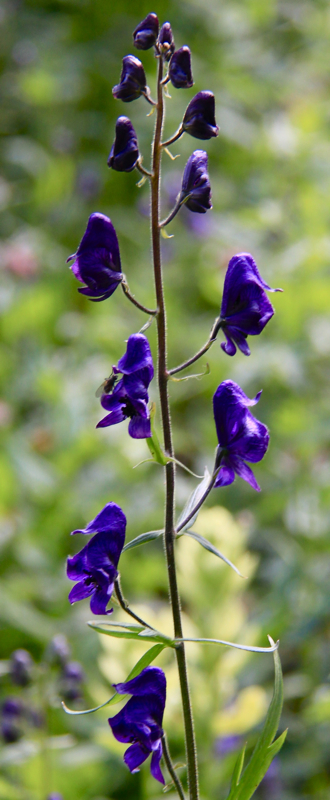
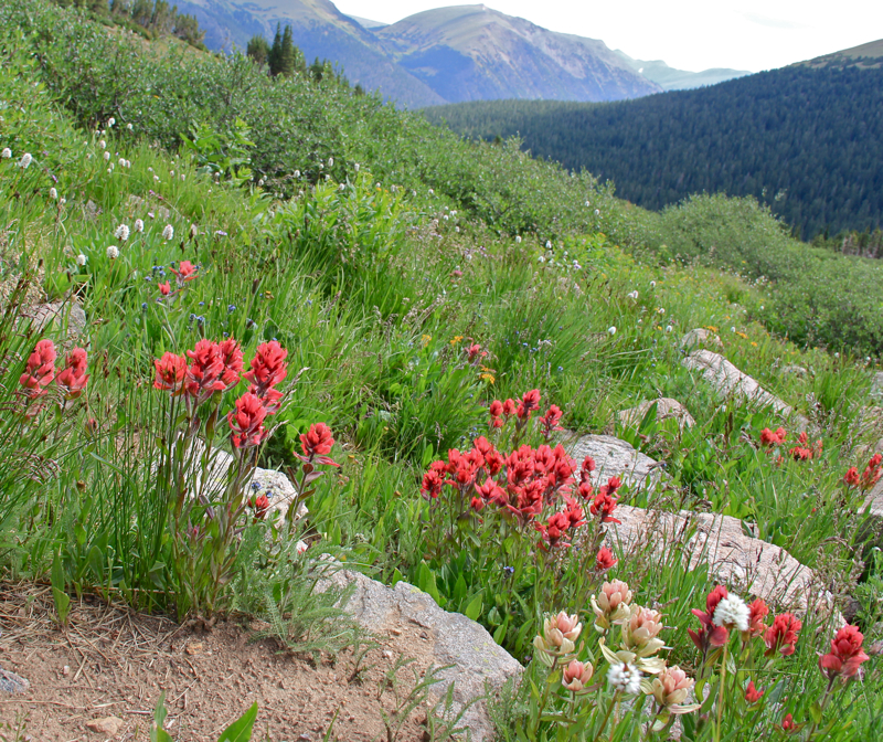
Indian Paintbrush and Bistwort create a colorful tableau 
An early trail segment
Along the way, the road will pass the Grizzly Gulch Trailhead.  You can climb Handies from this direction, but it is several miles longer.  There is a bathroom at this trailhead, which also serves Sunshine and Redcloud.  Four miles or so beyond this point is the turn off to American Basin.  This road is also 4x4 and is particularly bad just before the large trailhead. After the drive, climbing Handies was a piece of cake!

More wildflowers
Looking back down on the route
Early morning glare at the basin perpendicular to American Basin
The initial part of the route heads into the back side of American Basin, hugging the left side. Wildflowers abound here and it was difficult to keep going because I wanted to stop for every colorful tableau. With the weather pressing, there was no time to waste, however, so we pressed onwards.  At the start of the basin is a large rock glacier, which resembled a large amoeba oozing slowly downhill.  Rock glaciers are different from ice glaciers in that the water is not a solid mass, but exists between the rocks so all you see is flowing (in geologic time) rock.

Starting across the basin
Looking back down on the route
Heading up further
Looking back down on the shelf and entrance to American Basin
Before reaching the rock glacier, the trail banks to the left and climbs steeply up to the shelf (at 1.26 miles) to a cirque that is perpendicular to American Basin.  A smaller rock glacier graces its upper slopes.  The route will actually climb to the right of the basin and then down and across the rock glacier to the other side.  At the top of the route on the right hand side is Sloan Lake (at 1.6 miles and 12,941 ft), which is a destination itself.

Climbing 14ers is fun!
Crossing the rock glacier.  The trail will descend sharply and then ascend again across the glacier up the slope in the distance. 
Looking back at Sloan Lake.  The trail from the shelf to the lake is just visible in the distance. 
Once across the rock glacier, the route switchbacks steeply up the side of Handies.  Green tundra grasses and views back down the route make this segment pleasant indeed.  At the top is a saddle with a primeval view of geologic marvels clawing their way upwards from the valley below.  Is this Valhalla? Surely we are above the cares of mere mortals on such airy heights!

On the switchbacks to the final saddle
Approaching the saddle
The primeval view from the saddle
To the left is the final summit ridge.  It is smooth and steep.  Steep as in Sniktau steep.  I dug out my hiking stick and used it to anchor myself as I plodded upwards.  It was hard to turn around and admire the view.  I passed a woman coming down who was afraid of heights.  She was trembling with each baby step downwards.  I began to get nervous but the decent down this pitch but it was actually very easy, so don't let the steepness bother you.

The summit (second hill) viewed from the saddle
Heading up the summit ridge
This view makes the summit appear very close...but is it?
Heading up the steep section
The view from the summit is grandiose.  Jagged mountains abound and we had the place to ourselves, a rare treat in Colorado. Unfortunately, we had Armageddon brewing directly over us, despite our 5 am wake-up call and hardly spent any time on the summit.  I felt comfortable, and infinitely safer bolting downwards after a few hasty pictures.  Therein lies a life metaphor.  Rarely do life's struggles lead us to lasting rewards.  It is the tenuousness of any achievement that reminds us that like Handies life is more about what happens along the way.  

Looking back down from half-way to the summit
Almost there!
View from the summit
The weather held long enough for us to dawdle on the decent.  We stopped at Sloan Lake, which I will turn into a post of its own, watched Marmots frolicking amongst the wildflowers, practically stepped on a flock of Ptarmigan, and stopped to gawk at a trio of baby marmots just starting to explore their world.  By the time we reached the truck it was starting to pour.  Good timing indeed.

The author (left) and Elaine reveling in Colorado glory!
Lynn enjoys the summit
Climbing Handies is so full of view-gasms that I recommend everyone, not just 14er peak baggers, to consider this experience.  I will leave it up to you how to get to the trailhead.  A private helicopter would be my personal choice.  You can pay for the trip in what you save in post-drive therapy fees!

Back down in American Basin, a cheering squad of Frosty Ball Thistle waved us by. 

North Rock Creek Snowshoe

Distance: 4 miles round trip Elevation: 9,180 ft to 9,780 ft Elevation Gain: 600 ft Dogs: Off leash until the wilderness boundary North...