Monday, May 25, 2009

Gem Lake

Distance: 3.4 miles round trip
Elevation: 7,882 ft - 8,830 ft
Elevation Gain: 948 ft

Gem Lake is small but scenicGem Lake

Gem Lake is one of my favorite hikes in Rocky Mountain National Park. It traverses an unusual igneous rock formation called Lumpy Ridge and reminds me of my youth hiking in the Sierra Nevadas.

Example of the well-maintained trail

Looking south from the trail. To the left is Twin Sisters, behind the large hill is Estes Cone, and the snow capped peaks are Longs, Meeker, and Mount Lady Washington.

The park has changed the trail head for Gem Lake since I last hiked it in 2006. There is a new, paved trailhead (Lumpy Ridge) with a nice bathroom and sign. Both the old and new trailheads are still on Devil's Gulch Road, which is right after the Stanley Hotel (see photo on my Winter RMNP photo shoot). The old trail used to skirt private property and wander by several homes. The new trail has a more natural feel to it and starts out right next to a large igneous boulder field.

The trail crosses large rock plateaus in several spots

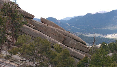
Angled rocks. View is looking south east.

Gem Lake is a easy trail, and I will often take new hikers on it because the views are spectacular and the rocks add interest all along the way. Typical of trails in the park, the route is well maintained although towards the end, there is a section of high steps that would trouble someone with knee issues. Most of the trail is sandy with occasional traverses of broad rock plateaus.

A flat portion of the trail

Is this natural, or created by some ancient Atlantian civilization?

Besides the towering rocks, views of Estes Park and the surround peaks are visible from several locations. These would make an ideal al fresco dining spot for those more interested in lingering over a picnic lunch.

There are young aspens along the trail.

Paul Bunyans' boot. I knew someone that scrambled up this large rock and stuck his head through it. It is larger than you think.

Gem Lake itself is more of a pond and not a very spectacular destination. It is surrounded by rocks but compared with other high alpine lakes in the park, just does have the same appeal. It really is the route itself that is the appeal of the Gem Lake trail.

Faces in the rocks

Nearing the top, the rocks grow more dramatic. This wall is to the west.

There is a feisty inhabitant of the Gem Lake area and that is the Golden-mantled Ground Squirrel (Spermophilus lateralis). On a trip back in 2004, they were everywhere and were literally climbing into people's packs, climbing up their pant legs etc., all in an attempt to gather morsels of forbidden sandwiches. On this trip we did not see any, but we did not stay at the lake for long either.

A broader view of the Estes Valley and Peaks

The rock wall to the right of the trail just before the lake

The other nice feature of Gem Lake is that it is lower in altitude than other trails so it is suitable for the late fall or early spring. For a longer hike, one can head down the back side of Lumpy Ridge to Balanced Rock. I have done this once and found the trail somewhat monotonous, but since Gem Lake is short, the added excursion will at least give you mileage.

A Golden-mantled Ground Squirrel taken in 2004. At one point this little gal climbed up into my lap.

If you are visited the park for the first time and live at sea level, I would consider doing Gem Lake as one of your first hikes. It is short, lower in altitude, and the views will give you a perspective on the more traveled southern part of the park.

Friday, May 22, 2009

Cottontail Rabbit


Spring is here and the rabbits are breeding well...like rabbits. I am seeing them on every trail, under every shrub in the neighborhood, and in the glazed eyes of my dog as it dreams on the couch. Cottontails (Sylvilagus sp.) give birth to two to six litters every year with five young'ens per litter. That is up to 30 new rabbits a year from every female. Thank goodness for carnivores!

It seems like everything preys upon the poor little rabbit including humans, which kill over 50,000 a year. For the Cottontail it seems, life is a continuous war zone. I was surprised to learn their life expectancy is only a year. No wonder they breed like crazy.

There are three species of Cottontail in Colorado and they are impossible to identify in the field. They live in the mountains, plains, and deserts.


These pictures were taken on the Bitterbrush Trail. This specimen was standing outside its burrow when a biker came up. He said he would distract it while I swooped in for a picture. It worked. Now, if I can only get my hiking partner to do the same thing with that Mountain Lion I have always wanted to capture on film.

Cottontails are herbivorous and eat a variety of grasses. They also love to munch on your just planted flowers, garden vegetables, or other important greens.

Monday, May 18, 2009

Bitterbrush Trail (Hall Ranch)

Distance: 5.5 miles round trip out of a possible 7.4 miles
Elevation: 5,499 ft to 6,179 ft
Elevation Gain: 680 ft

The mesas of Hall Ranch Open Space

I used to hike Bitterbrush a lot when I lived closer to Lyons. It has an “old west” feel to it because of the large eroded bluffs near the trailhead. It also climbs over a large formation of igneous rock, which I found particularly appealing.

The beginning of the Bitterbrush trail

On this trip however, I felt like I was trying to hike on the Los Angles freeway, there were so many mountain bikers lunging down the trail or struggling up it. It really was a distraction. I know it was a very nice day and bikers have a right to exist too, but geesh, you would think they could at least have some manners. Half the time we were not aware of the bikers until they were practically on top of us. At one point I had to leap off the trail and into a large prickly tree trunk to escape total annihilation. The bikers must have recently “discovered” this trail because in all my time hiking it, I had never seen this many.

Igneous rock in the switchback section. This area is flat, much of the area was not.

Blooming cactus on the trail

Bitterbrush is a low elevation hike, which make it suitable for the spring and fall. Right now with all the hills green, it is particularly attractive. I was amazed too how much wildlife we saw. There was tons of Mule Deer, Cottontail Rabbits, Prairie dogs, and even a juvenile Golden Eagle.


Looking west from a view point on the switchback portion
Above the switchbacks, the trail becomes a wider road through open meadows

The trail starts out near a very nice picnic facility. I have always wanted to have a group BBQ there because of the large protected tables. After a half-mile traverse of the open meadows the trail ascends a large series of switchbacks. These switchbacks are imbedded into a large igneous rock formation. At times there are nice plateaus and at other times deep ankle twisting cuts. Throughout, Ponderosa Pines scatter the hillside. There were only a few wildflowers out but you could tell more were on the way.

Vista near the intersection of the Antelope Trail

At the top of the hill, the trees fade and the trail, now much wider, skirts a hillside with expansive views to the west and north. At 2.25 miles is the junction of the Antelope Trail. Continuing drops the hiker 100 feet or so down into a meadow. This is home to the highest Prairie dog colony in Boulder County.

Deer in the meadow

We decided to head down for another half mile and ended up turning around at one of the Prairie dog interpretive signs.

Looking north from the highest point. The Antelope Trail is off to the right through the trees. There is a bench along the trail in the lower left portion of the picture.

Because it is so open, Bitterbrush makes a great winter hike. Unless we have a major dumper, there is usually little snow.

Down in the meadow heading northwest

Please note, that this is a non-doggie trail, which is another reason I have not hiked it much lately. It may also be the reason that so much wildlife was present.

Even more deer on the return back through the switchbacks. I would have thought the continual stream of bikers would have disturbed them, but they seemed non-pulsed.

Thursday, May 14, 2009

Lubahn Trail

Distance: 2.5 miles round trip (official trail), 3.0 to 3.5 miles round trip with extension depending upon your route
Elevation: 5,676 to 6,319 ft
Elevation Gain: 400 ft (official trail), 643 ft (to Castle Rock)

Fellow hikers atop Castle Rock looking towards Denver, which can be seen in the distance

No one ever hikes the Lubahn Trail by itself. Instead they use it as the primary way to get part way up South Table Mountain in Golden and then use one of the many unofficial trails to the top of Castle Rock (formally known as Table Rock). According to the city, this additional excursion is illegal because it traverses private property. Tell that to the 30 or so people on the trail the day I did it.

View of Castle Rock from the street below

Every time I visit Golden I have wondered what the view would be like from a top Castle Rock, an obvious rocky outcropping on the top of South Table Mountain. There is a lot of history behind that hunk of rock as well.

Starting out to the right

Heading up

The last pitch to the top. The dirt was very loose here.

In 1906, the Castle Rock Resort opened on top of South Table Mountain. Because the locals vehemently opposed a liquor license, it started out as a café. Tourists rode donkeys up the cliff face to sip on cappuccinos.

Past the outcroppings, the trail flattens and spreads out in all directions

By 1913, a railway had replaced the donkeys and for 25 cents a tourist could ride to the top and gamble at a casino.

Approaching Castle Rock

In the early 20’s, it became a segregated dance hall and illicit drinking establishment but business was not good and soon the KKK took over the area for their meetings. In the largest event over 1,000 Klansmen frolicked atop the mountain and a large cross burned on top of Castle Rock. Who knew sleepy Golden had such a torrid past! When the structure at the top finally burned down in 1927, few wept.

Closer now

Old stairs

Today, the journey to the top of South Table Mountain is a pleasant if brief workout. The day I climbed it, I was in quite a rush. I had just finished a Sierra Club meeting and wanted to get a jaunt in before racing home to get the dogs and take them to the dog park for their daily regiment.

View looking northeast. Coors Brewery is down in that valley. Note that Golden does not look like the pristine mountain scenery Coors uses in its advertising.

The trail is typical of Front Range trails. It was dusty, rocky, and poorly maintained in places. The Lubahn portion of the trail is a loop and I started off of Belvedere Street and headed to the right.


View to the north and parts of Golden

As the trail climbs, the views of Golden become more expansive. At the southern extent of the loop, the trail begins to switchback and heads relentlessly up to two rocky outcroppings. The official Lubahn Trail heads back to the left here but the unofficial trail heads straight up. There are no signposts, or obvious distinctions to differentiate the two. For a while Castle Rock itself disappears behind the side of the mountain. The last pitch up between the outcroppings is straight up and filled with loose dirt.

Looking down on the Lubahn Trail. I descended via this route.

Once on the top, the hiker is presented with a series of intersecting trails that head off in all directions. It is easy to find you way, however, just find the nearest trail that heads off to the left. This portion of the trail is on the wide top of South Table Mountain. It is filled with grasses and occasional small shrubs.

Looking back up at Castle Rock from the descent

There is an obvious train of folks heading to Castle Rock, which has a series of short concrete steps leading to the top. These are the remnants of the old dance hall.

Heading down and looking to the south

On the top, Castle Rock just appears to be a large rocky ledge. The views of Golden are very nice and you can look down onto Coors Brewery as well. Some leftover yokels from days gone by have graffitied the place here and there, detracting from the natural ambiance.


I hiked this trail in late March when the weather was warm and the promise of Spring was in the air.

Because I was in a rush, I headed back down and met my friends who were just arriving. They had taken the left route up the Lubahn Trail and taken the most direct social trail to the top. This would be the trail that I would take down. It was precipitous in spots and not suitable for folks with knee problems. At the bottom of this section of the Lubahn there are few interpretive signs that discuss the geology of Golden’s mesas.

Sunday, May 10, 2009

Black-tailed Prairie Dog

All the world loves baby animals. I have never seen baby Prairie dogs. The entire litter is here checking out the big, wide world.

Happy Mother's Day to all the mothers out there in the natural world who work so hard to perpetuate the species. It is a thankless job no matter what "team" you play for.

These Black-tailed Prairie dogs (Cynomys ludovicianus) were born close to 30 days ago. They were the size of a newborn kittens and just as curious. They were too naive to know that a large towering biped approaching their hole was a potential threat and let me get within 10 feet of them. Had I been a carnivore, these young ones would have been dinner. At another location, the babies were well protected by sentinel adults that started "barking" the moment I got too close. The only adult I saw in this area though was above ground and foraging 10 yards away.

The specimen on the left shows just how tiny these pups were.

Prairie dogs are not canines, but rodents. They earned their name precisely because of noisome warning cry. There is a trail I like to run in Boulder that traverses a large group. I feel like an ultra-marathoner being cheered on by the crowd every time I pass through. The cry is rather high-pitched though and very annoying...just as Mother Nature intended.

Prairie dogs are very social and live in large underground colonies. These can grow to be over 100 acres. Like any good solider, they clear all the vegetation away from their "fort". That is easy to do for the grass-chomping Prairie dog.

An adult. Half hidden in the burrow, you can see how bulbous they look above ground. Fashion models they are not.

Prairie dog burrows aerate the ground and funnel run off into the water table, thereby reducing erosion. Prolific diggers, their tunnel systems can descend as much as 16 ft and traverse as much as 100 feet. The tunnels also provide homes from other animals like the Burrowing Owl. These tunnels combined with the Prairie dog's tendency to take over all available space have turned them into a pest in modern society. Even Boulder, animal-loving capital of the universe, struggles with what to do with them. There is no way to contain them to open space. They move in to schoolyards, trails, soccer fields, and airport runways.

There must be millions of Prairie dogs in Colorado. The Black-tailed is the most prolific but two other species, the White-tailed Prairie dog and Gunnison's Prairie dog also live here. The infant photos were taken on the Bitterbrush Trail (Hall Ranch) in the highest colony in Boulder County (at 6300 ft). The adult photo was taken at a local dog park.

Tuesday, May 5, 2009

Bent’s Fort (circa 1833-1849)

Bent's Fort seen from the parking lot. This amazing reconstruction was built in 1976.

Bent’s Fort, near La Junta, was a major trading post along the border between the United States and Mexico. That’s right, before the invasion of Mexico in 1846 the Arkansas River was the border! I never knew it was that far north.

The approach to the fort traverses a large marsh. There is a trail around the marsh, but the weather prevented the journey.

The marsh was filled with Red-winged Blackbirds (Agelaius phoeniceus), strutting their stuff.

The fort also sat on the Santa Fe Trail, a major trading route that spanned the country. In the present day, the Trail cuts right through La Junta and nearby you can walk the old trail and see the old stone markers. Closer to Trinidad, you can see wagon ruts. The Santa Fe Trail was not an emigrant trail like the Oregon Trail in Wyoming. It was strictly trade goods, the prime commodity being Buffalo hides.

The approach to the fort

Standing inside the entrance, looking to the right

My visit to Bent’s Fort has changed my opinion on the near extinction of the Buffalo from the great plains of the United States. I had always been taught that the westward expansion of the White Man into the Plains Indians’ territory produced an orgy of killing that eventually wiped out the Buffalo. The Indians wanted to preserve the land and its inhabitants, while the evil White Man, then as now, wanted to destroy it. What I learned at the Fort was a new twist to this sad tale.

Trading Room. Here Buffalo hides were traded for guns, kettles, chocolate, corn, knives, flint and other goods.

The Indians themselves, in a lust for European trade goods, did much of the killing. They were far more adept at tanning the hides, which was a very laborious process. Contrary to myth, they did not use every part of the Buffalo when killed for this purpose, there was just too much. One could argue that it was the White Man who put the lust in the Indian’s heart, but if the culture, religion, and habits of the Indian were so much more environmentally conscious than white society, they would not have been tempted. The reality is, the Plains Indians were no less human than anyone else. They were influenced by the same passions and the same vices. To idolize them for being above such banalities is misguided.

Carpenter's Room. After the long journey from Missouri, I am sure many a traveler had need of this "auto body shop".

During the fort’s heyday, it teamed with activity. The Bent’s were very fair and adept peacemakers. Their egalitarian approach to business, rare in its day, made business thrive. At one point the Arkansas Indian Agency made the fort their headquarters.

Dinning Hall: Ah, the lure of civilization in the wilderness. The Fort Cook also hosted numerous "fandangos" where all manner of society mingled in a most undignified manner. After dinner many retired to the...oh horror...billiard room.

In 1846, the year of the Mexican-American War, the fort was used to house soldiers and their supplies. In unfortunate modern parallels, they over consumed what the land could provide. The fort never really returned to its peaceful ways. Some sort of military presence was always there. Shortly after the war, gold seekers and settlers took their toll on the area as well.

Standing in the courtyard looking at the entrance. It was these storm clouds that prevented us from hiking Picketwire Canyon.

On this trip to Bent’s Fort, we saw only the two National Park Employees, dressed in period costumes and no one else. That is not a realistic depiction of the fort, which was crowded and noisy with the tones of five or six languages. Behind the fort was a corral filled with the braying of pack animals.

The Buffalo hide press. Note the colorful Park Ranger in period costume. He was always posing like this.

By 1849, much of the Buffalo was gone from the immediate vicinity of La Junta and most of the trees had been destroyed. It was believed that Charles Bent burned his own fort after an unsuccessful attempt to sell it to the US Army.

Standing on the ramparts looking down into the courtyard

View of the marsh from the ramparts

A trip to Bent’s Fort is well worth the effort, particularly if you combine it with a trip to one of the canyons in the area. Vogel and Picketwire are particularly noteworthy.

Standing on the northwest lookout and looking back into the corrals. Turn around and one would see the corrals complete with horses and donkeys.

North Rock Creek Snowshoe

Distance: 4 miles round trip Elevation: 9,180 ft to 9,780 ft Elevation Gain: 600 ft Dogs: Off leash until the wilderness boundary North...