Tuesday, July 22, 2008

Bear Lake to Odessa Lake to Moraine Park Shuttle

Distance: 9.2 mile shuttle
Elevation: 9,475 ft at Bear Lake, 10,675 ft at Lake Helene, 10,020 ft at Odessa Lake, 9,530 ft at Fern Lake, 8,800 ft at Fern Falls, 8,150 ft at Moraine Park.
Elevation Gain: 1,200 ft
Bathroom at Trailhead: Yes
Dogs: Not allowed (National Park)
Date Hiked: 28 June, 2008

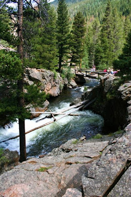
Odessa Lake from the overlook
This classic shuttle hike in Rocky Mountain National Park is part breathtaking adventure and part death march. It starts at Bear Lake, goes up to Lake Helene, then down to Odessa Lake, Fern Lake, Fern Falls, the Pool, and then finally Moraine Park. The trip to Bear Lake and the return from Moraine Park is via the park’s shuttle bus, so you don’t have to worry about bringing extra cars.

The trip starts at Bear Lake
This route has all of the elevation gain up front. There is a 1,200 ft of elevation gain in the first 2.5 miles, with the steepest section being in the first 0.5 mile. At this point the trail splits off with the left heading towards Flat Top Mountain (a worthy hike), and the right heading towards Odessa Lake. This part of the trail is mostly in the trees. One of the folks on this particular trip mentioned he loved walking in the trees and seeing all the dappled sunlight. I am glad he was enjoying himself because I was falling asleep and wondering how far till the views. I am a spoiled Coloradoan for sure. I want to be dazzled by tundra and peaks.

You know you are close to the gorge when you reach this small lake on the right.  Across from the lake you can see a rock field and Notch Top Mountain. 
You know you are getting close to the views when the trail breaks out of the trees in to a wide meadow. To the left you can look up and see the two distinctive rock piles on the Flat Top Mountain route. On this trip, this meadow was still blanketed in several feet of snow.

Specular views abound on the overlook reached via the social trail located off to the right of the main trail. 
Shortly past this point is a small lake off to the right. This is a nice spot for a water break. At this stage I was beginning to perk up because I knew the views were just ahead and what views they are. Odessa and Fern Lakes lay within Tourmaline Gorge, a majestic valley filled with peaks (Flat Top, Notch Top, and the Little Matterhorn), lakes (Helene, Odessa, Fern), and waterfalls (Grace, Fern, and Marguerite). In my opinion, this gorge is one of the the most dramatic places in the park. If all you did were to hike to this point, the trip would be worth it.

Lake Helene
Just before Lake Helene (on the left) is a social trail that feeds off to the right. This trail ascends to a small rock pile upon which is a broad shelf suitable for an alfresco dinner party for you and 10 of your closest friends. This lookout provides a 270-degree vista both up and down the gorge. Odessa Lake sits far below like an oasis among the pines. Grace falls is clearly visible part way up the slope of Notch Top. Upon Ptarmigan point, the snows still clung in a delicate cornice.

Grace Falls
If you can tear yourself away from the view on this lookout, do take the short trail to Lake Helene to the left of the main trail. You will find at the stream crossing a peak into the lake that seems flush with the eye. The trail does continue around the east side of the lake, which affords a close up of Grace Falls, almost wispy in the distance.

Trail down to Odessa Lake
At this point the trails descends sharply down through rock and skree, hugging the west side of the gorge. Around a third of the way down, there is a snow bank that remains late into the season. It was particularly thick on this trip and it we had to go off trail thirty feet or so to cut across it at a shallower angle. These sorts of snow banks are no fun when slippery from the sunlight. A pole eases the crossing. The trail does eventually return to the trees on the final approach to Odessa Lake.

Crossing the snowbank with Notch Top Mountain in the background
The trail to the Odessa lake splits off from the main trail and backtracks sharply back down the gorge. The short trip to the lake is a scenic wonder in and of itself. It follows a bustling stream embraced by Chiming Bells with the Notch Top Mountain providing a majestic backdrop. The southern shore of Odessa Lake contains a wide, sandy “beach”, which is perfect for a group lunch. The view here is unparalleled. The far northern shore of Odessa Lake is marshy and glitters verdantly in the sunlight. When I am Odessa Lake, I am filled with calm and am always thankful this little piece of heaven is in my back yard and most importantly is far from the hordes of visitors that invade the Glacier Gorge section of the park every summer. At this point in the journey, we had covered 4.1 official miles. I say official because the jaunt to the overlook, the walk around Lake Helene, and a stroll around part of Lake Odessa is not covered in the overall mileage in this pre-GPS description.

The creek into Odessa Lake
It is only another 0.6 miles from Odessa to Fern Lake. The trip is mostly through the trees but it is here in the shade of boulders that the wildflowers seem to grow. On this trip the most common were Columbine, Tansy Aster, and Indian Paintbrush. The best part of Fern Lake is the approach through a large boulder field. Fern Lake, while attractive to anglers, is less dramatic than Odessa Lake primarily because it sits lower in the gorge and most of the peaks are partially obscured by trees. An attractive backcountry ranger cabin is here but alas they don’t serve ice cream from the porch. On this trip I would have paid handsomely for some ice cream for it was very hot and very buggy. I am not used to bugs in the Rockies but this years late snows have seemed to have made them particularly numerous and voracious.

Odessa Lake viewed from the "beach"
For me, the journey from Fern Lake to Moraine Park is a death march. The trail is rocky, steep, buried in trees, and monotonous. It is 1.1 miles beyond the lake before you reach Fern Falls. For sanities sake, you’ll want to linger here a bit. Fern Falls is decent waterfall. It is tall and broad and is the primary destination for folks heading up the Fern Lake Trail from Moraine Park.

Fern Lake
Another mile beyond the falls brings you to The Pool, which is a welcome break from the grind. It is a small gorge filled with churning water. Several large rocks surround it, suitable for baking in the sun on a cooler day. On this trip I had to stop myself from jumping head long into the ice-cold tumult.

Twin Flower (Linnea borealis) grows in cold woods and bogs. It blooms from June to August. At this point on the trail we were approaching Fern Falls and things were getting more moist
The last slog back to the Fern Lake trailhead is 1.7 miles. The terrain is very different here than higher up the gorge. Ferns abound, the creek is broad and wide next to the trail and there are some interesting boulders to walk through. Still, by this point, most adventurers are foot sore. The last time I did this trip, we were caught in a raging downpour. I would have gladly accepted such a dunking on this trip because it was indeed hot. I think Denver had reached a lofty 102 that day and the elevation of Moraine Park was not cutting the heat by much.

Fern Falls
The cars at the Fern Lake trailhead were a welcome sight and we took a moment to sit on one of the benches to rest and prepare for the least fun part of the hike. It is another 0.7 miles up the dirt road to the shuttle point and after a long day, this segment can seem more arduous than any difficult 14er. Fortunately, I was with a large group and we were discussing our post-hike food options, which put pep in my step and made the trip less trying that it otherwise would have been alone.

The Pool
In all honesty, I prefer to hike down to Odessa and back up to Bear Lake when I hike alone in this part of the park, but most people prefer the shuttle because you get to see it all, and you don’t have to back track up hill. I have never done this shuttle going the other way, starting at Moraine Park and ending at Bear Lake. It certainly would be a better training hike that way, gaining 2,600 feet of elevation by the time you reach Lake Helene. One of these days I will do that. If you don’t mind trees, this shuttle hike will be glorious from start to finish. If you are finicky like me, then it will be a mixed bag. Everyone should do it at least once however. It is a quintessential Rocky Mountain National Park experience.

Sunday, July 20, 2008

Poison-ivy: “Leaves of three let it be”


All of us have itches we really shouldn’t scratch. Vaporizing the slow driver in front of me or breaking into my neighbors wine cellar and binging on Bordeaux are itches that plague me repeatedly but that I manage (so far) to avoid scratching.

A Poison-ivy (Toxicodendron radicans) rash is another thing one should avoid scratching. Obviously, the best way to ease this temptation is to avoid having it in the first place. Hence this post. Poison-ivy infests the Mesa Trail this time of year and does not always stay neatly on the side of the trail but in several locations grows between the rocks in the middle of the trail. I have seen many hikers blissfully rubbing ankles with the leaves.

Poison-ivy has and oil called urushiol on the leaves that react most unpleasantly with human skin. Contact with the oil either through touching the plant or touching something has touched the plant (e.g. your dog, your clothes) can also transfer the oil. One should note that it is not just the leaves but also the vines and roots contain this oil.

The rash caused by Poison-ivy can be a small itch or a big itch. It really depends upon your immune system. Some people get a small spot of oil on their skin and they will have a small itchy area. In others, this small exposure will cause a full body reaction. Still others seem to be immune. There are various pharmaceutical products out there to treat a Poison Ivy rash. Best to talk to your Pharmacist to determine the latest greatest. The rash can last from one to three weeks.

Poison-ivy has three green almond-shaped leaves that grow in a cluster, which is the source of the mnemonics “Leaves of three…let it be.” The leaves in our area are straight edges but I have seen pictures where the leaves are crenulated like Poison Oak (west coast), so don’t let that fool you. There is a definite sheen to the leaves that can make them shinny. In the fall the leaves can turn reddish. Note they do not make an appropriate Thanksgiving table display. The oil can remain active for years after the plant is dead so be cautious handling it.

Friday, July 18, 2008

Mt. Sniktau

Distance: 4 miles roundtrip
Elevation: 11, 990-13,234 ft
Elevation Gain: 1,675 ft (net) 2,147 ft (cumulative)

(Left: View from the summit) Mt. Sniktau as a great introductory peak for anyone wanting to train for higher endeavors. It is close the Front Range so you don’t have to get up in the middle of the night and the trail is relatively short so you can get acclimatized gradually. In fact, I met a couple from Montreal on the trail for this exact purpose. I chose this hike because I have passed the trailhead many times and have just been curious about getting “up there”. The trip was delightful despite some pressure from the weather and I would recommend it to anyone fit enough to roam above tree line.

The trail starts on the west side of Loveland Pass. There is a large parking area there that was empty when we arrived at 7:45am but that was packed when we returned. You could tell there were many lowlanders marveling at the pass and wandering about the knolls right next to it.

Guidebooks will tell you there are two false summits on the way to the summit of Mt. Sniktau and this is technically true. When you look on a topographic map there are two obvious summits, one at 12,915 ft, one at 13,152 ft and the final one at 13,234 ft. On the ground, however there are many more knolls, bumps, and talus piles that make it difficult to determine how many “summits” one has traversed. The main thing to remember is that the final summit is not visible until you are on the second of the “official” false summits and that it is a large triangular hunk of rock. All the other knolls and summits are very rounded. You also have to descend 100 ft or so from the second “official” false summit before you can ascend the final summit. All the other milestones are generally upwards.

Looking up at the first summit from the beginning of the trail. The second summit is off to the left.

The first part of the trail ascends up a very steep ridge to the first summit at 12,942 ft. This ascent takes 0.94 miles so you are ascending 1,000 ft in less than one mile, which is good for separating out the mountain goats from the domestic goats. None of the day-trippers that infested the parking lot ever made it up that high. It is a lung and calf buster. Descending this pitch is much easier with poles because the ground is loose, slippery, and filled with small rocks.

Farther up the initial pitch

Every step upwards improved the view as the Continental Divide becomes more distinct. The tundra was green and filled with wildflowers. A few large snow banks remained but certainly nothing worth skiing. When we reached the trailhead we passed a skier starting out with a skis and heavy boots. I suspect he was going to be disappointed. All the snow banks were off the trail and did not impede the journey.

(Right: Finally, on the ridgeline). From the first summit at 12,942 ft the trail is a very easy stroll across a wide ridge. You can see the second summit off to the northeast. A trail also goes off to the southeast towards Cupid Grizzly peaks. That looks like a nice trip as well. One of those large talus piles exists about half way across ridge towards Sniktau. We skirted its edge on the way up and went straight over it on the way back. It is easy enough to navigate. Talus always has the potential to twist an ankle so don’t be complacent even when the piles are small.

The second official summit is deceiving. There is a large wind shelter there, a USGS stake in the ground, and a rock pinnacle. Without the ability to judge distance, we thought were on Sniktau and were looking at another 13er off to the left. This is wrong. While the second summit is above 13,000 ft it seems to be unnamed. We were also confused by the obvious deep decent from the second to the final summit. I know that for a 14,000 ft peak to be its own named peak there has to be at least 300 vertical feet between them. I do not know if the same rule applies to 13ers. I need to calibrate my sense of the vertical because I was thinking the decent to the ridge between these summits was greater than 300 feet when in reality is was closer to 110 ft.

Talus pile on ridge to the second summit

At this point we were torn because the sky was completely covered in dark cumulus clouds. They were not building very much but the clouds right over the summit were the darkest in our immediate area. We wasted way too much time vacillating over continuing on when we should just have been hiking. Finally, we decided to go on and it was a short 20-minute journey to the official summit. Another clue. You can see Eisenhower Tunnel from the official summit and not from the second summit. The other major view is looking south. There is small lake between Sniktau and Torreys, which is quite picturesque.

Trail above the skree to the second summit

Alas, we did a high-five, took a few shots and left the summit quickly. Sometimes I hate Colorado’s weather. After all that work it is nice to hang out for a while and being chased off a summit by the weather is a real downer. After leaving the summit, the clouds did begin to break up a bit. This enabled us to slow down and enjoy the scenery. It was not until we had reached that 12,942 ft summit that things started to get really dark. It was here that we met the couple from Montreal. They were heading up and we pointed out the dark clouds and indicated it was tricky to continue. They chose to go on even and we were scurrying downwards. This is always risky. Storms in Colorado can build very quickly. They may or may not produce lightening but 1.5 hours up a treeless trail is a dangerous place to be. As it was we saw them on the summit long after we had returned to the car. The storms had been building and dissipating so hopefully they survived. I would not have started up with that level of darkness to the clouds. If I had been leading a group of people I would have also turned around at the second summit rather than take a chance. Risking your own life is one thing, risking others is quite another.

View from the second summit

I really enjoyed Sniktau. Purists might think it is too short to be worthwhile. I for one want to do every trail and can find an occasion for every type of trail no matter the distance or elevation gain. Sniktau has great views and is really fun, which in itself makes it worthwhile. Had the weather been better, I would have taken that second trail that leads off towards the southeast from the first summit. That trail leads to another unnamed 13er. From peak there is a narrow ridge to Grizzly Peak.

Mt. Sniktau from the second summit


Wildflowers and views looking northwest

Wednesday, July 16, 2008

Missouri Lakes

Distance: 7 miles RT to the lower lake
Elevation: 10,000-11,550 ft
Elevation Gain: 1, 550 ft


Summer has not arrived yet at Missouri Lakes. We could not even get to the upper lake because it was completely snow bound. I have seen numerous pictures of the lake at this time of the year and they are filled with campers. This year only the hardy had pitched their tents between the drifts. Still, Missouri Lakes was a spectacular destination and we can’t wait to go back. The trail has everything a hiker could desire, waterfalls, steep canyons, raging water, meadows, mountain vistas, and wildflowers. There is no way to get bored on this trail because it changes constantly.


Waterfall near the beginning of the trail

The trailhead to Missouri Lakes is in the Holy Cross Wilderness and is a good hours drive from Minturn up two dirt roads. While my sedan made the trip easily, it was slow and there were hordes of ATVers all along the road. Take the mileage you see in guide books with a grain of salt and follow the mileage markers that the forest service has installed. The turn off to the actual trailhead (the second dirt road) is around 8 miles in. There is a brown sign that says Missouri Creek. This is a large and obvious sign, which means you can ignore the many unmarked side roads.


The gorge

Initially, the trail starts off gradually, stays in the trees, and follows the creek. It will begin to ascend sharply after a half-mile or so until it comes to a large picturesque waterfall. Above this fall was a small lake. The creek and a dramatic gorge dominates the next portion of the trail. With the snowmelt in full force, it was easy to see how the water could carve such deep structures. The second major stream crossing takes you across a large bridge that straddles the gorge. The water was pouring through the gap in a stampede of water molecules in a sheer panic to descend to lower ground. The roar itself was almost deafening. Past this bridge, the trail travels up the gorge and in several places was underwater. A little more volume and the trail would have been impassible.


The creek bordering the trail

At the head of the gorge is a series of green meadows infested with Marsh Marigolds. Logs occasionally lead hikers above the bogs but there is no way to traverse this trail without getting your feet wet. From this point there is a longer pitch through trees, around rocks, and over drifts. Here we met with an Outward Bound adventure. One creek was so swollen that it covered the trail. Someone had placed several mid-sized tree trunks across the creek balanced on the shore and a large rock in the center. There was nothing to grab on to and the logs were not much wider than my boot. They certainly were not flat. Fortunately, we arrived at this point just as other hikers appeared on the far shore. With help they pulled us across. I cannot image trying to manage that crossing with a large, overloaded backpack. Had I been hiking alone, I probably would have talked myself out of the crossing. Fortunately, I was not alone and we made it across. The view at the lakes was well forth the effort.


One of the lush meadows

Missouri Lakes is a series of 14 separate lakes and ponds but with all the snow it was impossible to distinguish anything but the largest of the lower lakes. The clouds kept building and dissipating behind Savage Peak but we were able to lounge on a large rock for almost an hour. It was not until much later in the evening that we ran into the rain. In fact the drive back to Denver was a white knuckled affair of hurricane-like downpours. What is it lately with rainstorms and holiday weekends? We ran into the same thing coming back from the Black Canyon over Memorial Day.


The far side of the lower (we think) lake

While the trip to Missouri Lakes makes for a very long day trip it was by far one of the most scenic hikes I have yet to experience in Colorado.

Monday, July 14, 2008

Northern Flicker


Every day on my way to work I have been observing two Flickers (Colaptes auatus cafter) feed on the grass boarding a retention pond. Flickers are ubiquitous in our area and are quite large, so they are hard to miss. I had a moment this morning to try and sneak up on them.


Flickers do commonly feed on the ground, using their large bills to probe for insects. There must be something very tasty in this one spot of grass because I see them there all the time. Perhaps there is an ant colony. Ants make up 45% of a Flickers diet although they will also eat berries, fruit, nuts.

Sunday, July 13, 2008

Yellow-bellied Marmot

A Yellow-bellied Marmot pokes its  head out from its lair
Yellow-bellied Marmots (Marmota flaviventris) are the sun worshiping denizens of the mountains. They are often observed sprawled indelicately upon a fat rock, their large bellies barely supported by the stone. After hibernating for 8 months I can see why. I too emerge from the winter sun-starved.

Marmots are actually ground squirrels and are related to the infamous ground hog. I suspect all our hibernating marmots roll over in their sleep when their distant cousin declares a longer winter. If a marmot’s fat reserves run out while hibernating, it will die. Alas, I have too easy access to chocolate, fine dining, and chicken wing binges to every worry about that! While late summer is my time to slim down, it is the time for marmots to gorge themselves on grasses, berries, lichens, mosses, roots, and flowers. How boring! They need to read some of my restaurant reviews. A diet of lichen is hardly fat building.

Adult Marmots are cute, but lets face facts, BABY MARMOTS are cuter!! I stumbled across these triplets, who all look like they had different daddies, on the trail to Handies Peak.
Mother marmot, who is significantly larger, watches us from behind a rock.
Marmots can be found at any altitude but prefer to live above 8,000 ft. They dig large burrows that have many entrances and exits. They line the burrow with grasses and fur to make it comfortable. These burrows are usually on rocky slopes next to meadows. Highly territorial, they did not want to move. Somehow the law of gross tonnage does not apply to marmots, they think they are bigger than they are. Perhaps they have a tail complex. At 6 inches I might have an ego too.

These little babies were living in and around an old mining train on the edge of Silverton Colorado. I have always wondered where Marmots go when they win the lottery. I just bet the inside is decorated with cabin kitsch...Moose trivets and throws, log furniture, a winter long stash of Jack Daniels, and a dog-eared copy of Murder on the Orient Express. 

Marmots are ubiquitous in the mountains. They will shriek at you if you invade their territory or look the other way as if you are not worthy of attention. The two that I photographed here seemed jealous of the mountain goats that I was following and kept posing like glamour girls on the catwalk.

Friday, July 11, 2008

Bumble Bee


I see far more Bumble Bees (Bombus bifarius bifarius) in Colorado than I do Honey Bees so I couldn’t resist trying to capture a few pictures of one as it lumbered from flower to flower at the Mesa Trail trailhead. Note that I did not say flitted, or bounced, or zoomed. The flight of a Bumble Bee defies logic and reminds me of a pimped out Hindenburg.

Bumbles are social insects even though you invariably see them feeding solo. Their colonies contain around 50 individuals and they will often feed up to 2 km away from their home. Since they return to the same flowers day after day, they leave scent marks warning other Bumbles away. Too bad human’s sense of smell is so retarded. I would much rather have gangs scent mark their territory than spray paint it.

Bumbles use a long tongue to suck out the nectar from flowers. This requires them to crawl over the flower’s reproductive parts and thereby collect pollen onto their legs. When they land on another flower this botanical groping results in the pollen being transferred to the new plant and the miracle of pollination occurs. Not only do the bees “do it”, they also participate in cross species manage-a-deux, which is very kinky if you think about it. Who said Mother Nature was boring?

Bumbles can sting just so you know and sting repeatedly like wasps. In fact only Honey Bees have the barbed stingers that result in Kamikaze death. Bumbles are not aggressive, however, and will only sting if threatened either while feeding or at their colony. Still, I find it best to get out of the way of any Bumble lumbering my way. Who knows what they see out of those compound eyes. Just hearing their buzz raises the hair on the back of my neck. In nature, a yellow and black motif is also a warning sign. Just so you know, a Bumble’s buzzing is not caused by their wings but by their flight muscles. It takes a lot of oooMPHF to move the Hindenburg.

So next time you are lying face down in a field of Colorado wildflowers take a moment to observe the Bumble Bee.

Bee Balm


I always regret the appearance of Bee Balm (Monarda media), also known as Wild Bergamont, on the Mesa Trail. It blooms in July and August but always seem to be the last flower to bloom in the season. A hybridized version is available for garden use, which has the reputation for attracting humming birds.

Monday, July 7, 2008

Mesa Verde National Park

Long House

People from all over the world travel to southwestern Colorado to see the spectacular cliff dwelling of Mesa Verde near Durango and Cortez. The dwellings were built by the Ancient Puebloan people (formerly known as the Anasazi). If you live in Colorado and have not visited this remarkable place, then shame on you! Don’t plan on visiting the park expecting a few death marches in between dwelling tours, however. The trails in the park are few and far between and short because much of the park is protected and even the Rangers are not allowed wander off to explore the hidden dwellings and ruins that are not open to the public.

Views looking northeast from the mesa

Mesa Verde was occupied between AD 550 and AD 1300. That is 700 years long folks! It is hard to fathom any community lasting that long. For the first 600 years, though, the Ancient Puebloans live on top of the mesa. The climate during that period was much wetter than it is now and large swaths of the upper mesa were used to cultivate corn and other crops.

There are four major cliff dwellings that you can visit. Each requires a separate ticket, which is purchased at the visitor’s center. Getting into and out of the dwellings is easy for some and nerve racking for others. For anyone who is afraid of heights like me, some of the cliff dwellings are more an exercise in anxiety control than anything else. I will try to describe each one individually.

The Cliff Palace is the most famous dwelling. It is also the largest with 150 rooms, 75 common areas and 21 kivas. It was home for 100 to 200 people. This dwelling is only accessible via tour, so be emotionally prepared to join the herd and be led around.

Cliff House

The Balcony House is the one cliff dwelling that requires Valium for those afraid of heights. There is a large 20-foot ladder that you need to scale to get into the dwelling. The Rangers are quite upfront when you purchase your tickets that this ladder presents problems for some people. My friend talked me into it and the Rangers are good about talking you through. The trick is to look straight ahead at the logs of the ladder and don’t have sunscreen on your hands because the logs are slick with use. Through much Lamaze breathing, I was able to make it up. Ironically, there is a cave you have to crawl through to get to the exit and my friend is claustrophobic so I had to coax her through that section. To get back up to the top of the mesa there is a series of smaller ladders. After surviving big mamma, these ladders seemed trivial. Each one led to a nice fat ledge that I could throw my body onto. One pitch did not end in a ledge, however, but ended in a chain cut into the rock. This so disconcerted me that I raced up the rest of the way on a surge of adrenaline. I could literally feel it pumping through my veins and it was a good six hours before it was all reabsorbed. The Rangers did not warn us about that so be forewarned! It did not help either that this was the first dwelling on the tour. I was paranoid the whole day that all the others would be similar. They are not. Balcony House is the only one you have to worry about if you are a nut job like me when it comes to heights.

Balcony House. Note the large ladder on the right of the photo and the other ladder up the cliff on the left.

Long House is only open in the summer. It is located twelve miles away from the other dwellings on Wetherill Mesa. There is a nice picnic area with a shaded pavilion in this area as well. You can choose to take the tram or to walk to the dwelling. Along the way, stop at the Badger House Community. This is an excavated mesa top dwelling under a canopy. There is also an overlook for Long House, which is always nice. Seeing the dwellings with their alcoves gives them perspective. Long House was quite easy to get into and out of. Here we saw the shallow pool that demonstrated how the cliff dwellers got their water…it trickled down through the rock from the mesa above. The shallow pool looked more like a salt lick than a hot tub, so the residents were not swimming in H2O.

Long House with alcove view

Spruce Tree House is the third largest dwelling. In reviewing my photos it seems that I did not take my camera with me that morning or was bored with taking pictures. Who knows? You’ll have to take my word that it too is worth walking through. There are no ladders at all for this dwelling.

On this trip to Mesa Verde, we camped in the park. The campground was practically deserted. I asked a Ranger and they said that that was typical even though it was the July 4th weekend. Because the park is on a mesa it cooled down nicely in the evenings. Durango is the nearest town to the Park but it is a long and tedious drive to get up the mesa. Camp or stay in the park at the 60’s looking retro lodge if you want to maximize your time. However you do it, everyone should experience Mesa Verde at least once in their life.

Sunday, July 6, 2008

Square Top Lakes

Distance: 4.2 miles round trip
Elevation: 11,700 ft - 12,300 ft
Elevation Gain: 850 ft (net), 1,100 ft (cumulative)
Bathroom at the Trailhead: Yes
Dogs: Off leash
Critters: Golden Eagle, White Crowned Sparrow

Square Top Lake is a great alpine journey near Denver.
Lower Square Top Lake as seen from the upper lake. Mt. Bierstadt in the background.
Square Top Lakes near Georgetown Colorado is a short tundra hike to two alpine lakes with incredible views. The entire trail is above treeline, which is always a treat for those like me who don't like slogging miles through the trees to get anywhere.

Looking down into the first valley
I chose this hike for the first hike of the 4th of July weekend because I needed to get my 15 year-old dog out for a short hike that was not overly rocky. Last year I had made it to the lower lake but ended up jogging back to the car as the thunder rolled overhead. This area is notorious for afternoon thunderstorms that will have you cowering in fear if you are careless and start late. On this trip, the skies stayed clear and I was able to lounge at the upper lake for an hour or more. There I saw a Golden Eagle flying against the mountainside. Even with my telephoto lens it was merely a spec against the expanse of rock.

Western Sky Pilot (Polemonium viscosum) on the Square Top Lakes Trail
Western Sky Pilot (Polemonium viscosum). It grows at high altitudes on dry rocky sites.
The trailhead for Square Top Lakes is at the apex of Guanella Pass. The lower parking lot is full of Mt. Bierstadt climbers and the upper lot contains overflow. Both lots have nice new bathrooms. The trail descends 100 ft into a small valley where is crosses a creek on a series of wooden bridges. It then rises quickly to a large rocky knoll. There were Buddhist payer flags strung across the rocks here and another hiker told me someone had died in an avalanche there. From this knoll, the trail descends another 100 ft before rising to the first lake. This lake is pretty, but the view from the upper lake is even better. Both lakes are nestled at the base of Square Top Mountain. That is an adventurous hike as well!

A small section of the upper lake
Wildflowers covered the tundra and at one point I tried to estimate their distribution. It seemed like there was one flower every six inches or so. I lost count of the number of species present but white and yellow seemed to be the predominate colors. On the broad shelf that borders the upper lake, tiny tundra flowers sprouted in crevices of every rock. I need to get myself a magnifying glass so I can examine these more closely.

The Alpine Sunflower is a tundra flower sure to please.
Alpine Sunflower (Hymenoxys grandiflora). Also known as Old-Man-of-the-Mountain. They bloom in clumps from May to June and turns to face the sun.
On my way back down I lingered at the lower lake for a few moments. There I met Jack, a Chesapeake Bay Retrieve/Lab mix. This dog looked more like a Grizzly Bear than dog and he was shuffling through the water of the lake backwards shaking his hindquarters in a most un-lady like manner. The owners said he was trying to loosen rocks on the bottom with his front paws. This activity, combined with piteous whines was a site to behold. Occasionally, Jack would thrust the upper half of his body underwater like a duck feeding on grass and come up spouting. At last, we saw Jack bound out of the water with a 10-pound rock in his mouth. I wish I were so easily entertained. Still, if I were caught moving my hindquarters in a similar manner, I would be arrested for disturbing the peace! This vignette might just convince you that Square Top Lakes is great for dogs.

The White Crowned Sparrow is a migrant.
The White Crowned Sparrow (Zonotrichia leucophyrus) is a migratory songbird that mainly eats seeds. There were many of them singing away in the willows. I have a better photo on my Mayflower Gulch Wildflower Hike
If you check out Square Top Lakes, go early so you won’t have to run from the thunderstorms, which can pop up very quickly on Guanella Pass. Another great hike nearby is Silver Dollar and Murray Lakes.

The rock hound


Thursday, July 3, 2008

Diamond Lake

Distance: 5.2 miles RT
Elevation: 10,100-10,940 ft
Elevation Gain: 840 ft


Diamond Lake in July looking south

Diamond Lake is a wildflower Mecca with hordes of shutter bugs circling round and around choice Columbine and Indian paintbrush much like Muslims orbit the Kaaba shrine. Depending upon when you go, you can find flowers lower down near the trailhead or up higher in the large meadow that borders the lake. Go too early e.g. May and June and you will end up trodding through large drifts of snow and soggy expanses of melt water. The lake itself can be shrouded in dark clouds at this time too, which does create its own photo opportunities. I suggest waiting until mid-July, however if you want to wallow in wildflowers.


The Colorado Columbine (Aquilegia ceorulea) grows in meadows, woodlands, rocks, scree from June to August. It is also Colorado's state flower.

Be emotionally prepared to feel the press of humanity if you join the Hajj on weekend. Not only must you get to the parking area very early, but also you will be bumped and prodded by the multitudes trodding by. The Fourth of July trailhead is also the starting point for Dorothy Lake and Arapahoe Glacier so for part of the route you will be joined by more serious hikers. Lake is stocked as well, so anglers join the procession to the lake, some carrying inflatable dinghies to float in.


Chiming Bells (Mertensia ciliata) blooms from June to August along streams and waterfalls.

The trail begins to climb right off the bat and the hiker will traverse small meadows and forested slopes. Flowers exist in both places so keep your eyes open for more rare finds. There are several water crossings that are not arduous and which attract their own flock of water loving flower species like the ubiquitous Chiming Bells, which grow in huge clumps anywhere there is water.


Indian Paintbrush (Castilleja miniata) can be found all over the state in meadows, sagebrush flats, and meadows. It blooms from May to September.

At 1.2 miles the trails splits. Take the left fork and continue until you reach a pleasant waterfall. At this point the trail bends back upon itself and heads back down the valley. I find this feature frustrating and don’t know why the trail does just head straight up to the lake with out looping back. This is a psychological impediment I know. It is hard for us driven Americans to ever think of going backwards. This back tracking is also the steeper portion of the trail. It is in a darker forest with fewer views. Early in the season this is also where the snow can linger.


Diamond Lake

At the top of this steep pitch is a broad meadow with logs strategically placed to protect the sensitive plants. The views return at this point but it is best to sally to the lake where there are plenty of places to sit and snap pictures. I particularly like the stunted conifers here, which are wind blown and artistic. Their flag shapes are testament to the winds that flow down the valley from the north. On more than one trip to the lake, I have been hailed on, so bring rain gear even if the weather is pleasant in the morning.


Diamond Lake in May. A lot colder and more snow

Like the participants in the Hajj, you will be spiritually renewed by your journey to Diamond Lake and if you can go on a weekday, then you will reach this renewal without paying the price without having to follow the butt of the person in front of you.

North Rock Creek Snowshoe

Distance: 4 miles round trip Elevation: 9,180 ft to 9,780 ft Elevation Gain: 600 ft Dogs: Off leash until the wilderness boundary North...